April, 2003
Proposed by the Auckland Wild West Coast Working Group,
a community-driven discussion group.
  Compiled by Jaci Fowler under the direction of the Auckland West Coast Working Group. Compiled by Jaci Fowler under the direction of the Auckland West Coast Working Group.
This report has been funded by teh Lottery Grants Board and prepared by the West Coast Working Group in conjunction with Forest and Bird.
PARTICIPANTS ON THE WORKING GROUP
Ark in the Park (Dr. Peter Maddison)
Auckland Recreational Fishers Association (Bernie Ward)
Auckland Regional Council ranger (Dave Hayes)
Department of Conservation (Warwick Murray; Emma Rush)
Local residents and/or ratepayers (Bruce White; Adrienne Kizanich)
Muriwai Residents and Ratepayers Association (Anna Mason)
Ngati Whatua (Margaret Kawharu)
Ornithological Society of New Zealand (John Simmonds)
Rodney District Council councillor (Christine Rose)
Save Piha Shellfish (Lacey Graham; Marilyn Trubuhovich)
University of Auckland biological scientist & Waitakere Ranges Protection Society (Sue Turner)
Waitakere branch of Forest and Bird (Ken Catt)
Waitakere City Council (Carol Bergquist)
Western Underwater Dive Research Team (Mike Percy)
Western Underwater Research Team & West Coast Plan group (Mike Percy)
Groups and individuals not represented on the Working Group who have been kept informed on progress include:
Chris Carter M.P.
David Cunliffe M.P.
Bob Harvey (Mayor of Waitakere City Council)
Nganeko Minhinnick (Ngati Te Ata)
Kahui-iti Morehu
Lyn Pillay M.P.
Te Warena Taua (Te Kawerau a Maki Trust)
CONTENTS
Working Group Participants 1
Acknowledgments 3
Introduction 4
Significance of the area (geology and bio-diversity) 5
Key objectives of the working group 6
Scope of the report 6
Land Governance in the focus area 6-7
Legislation relevant to the focus area 7
Values of the Auckland West Coast 7
Zone 1
Description 7
Geological Values 7-8 Ecological Values 8
Economic Values 9
Social Values 9-10
Cultural & Historical Values 10
Zone 2
Description 10
Geological values 11
Ecological Values 11-12
Economic Values 13
Social Values 13
Cultural & Historical Values 14
Zone 3
Description 15
Geological values 15
Ecological Values 16
Economic Values 16-17
Social Values 17
Cultural & Historical Values 17
Areas potentially warranting greater protection (Hot Spots) 17-19
Map: Hot Spots of Auckland’s Wild West Coast (Map no. 1) 19
Threats to Auckland’s Wild West Coast 20-22
Potential Management Options for Auckland’s Wild West Coast 23-25
Integrated management plan for Auckland’s Wild West Coast 26-29
Management model boundary options (1&2) 30-31
References Cited 32-33
Appendices 34-49
(*NB: incomplete – waiting on separate Iwi statements to be included in an Appendix)
ACKNOWLEDGMENTS
The two co- sponsors, Mayor Bob Harvey and David Cunliffe MP, have given tremendous support for the project. Also, the Deputy Mayor of Rodney, Christine Rose.
A number of experts in their field who have also contributed, including Bruce Hayward, Margaret Morley, Geoff Moon, Graeme Murdoch, Kirsty Russell, Sue Turner and Ewen Cameron.
Thank you to all representatives of the Auckland West Coast Marine Park working group. The Working Group is made up of a number of representatives from a variety of stakeholder groups including; Department of Conservation (DoC), Forest & Bird, Iwi, Ornithological Society of New Zealand (OSNZ), Recreational Fishers, Resident and Ratepayer Associations and University researchers (full list of names before contents page). All have given their time and negotiated with the groups they respectively represent.
Thank you also to the Waitakere Ranges Protection Society and The West Coast Plan Group.
To all others who have helped move the proposal along, thank you.
INTRODUCTION
Greater marine protection for the Auckland West Coast is urgent. Located just 40 minutes from New Zealand’s largest metropolis, the outstanding wilderness illustrated in this report is nowhere so close to so many New Zealanders. The Auckland, urban metropolis is continually growing, which will make the social values enjoyed in this wilderness backyard even more precious and rare. This report has been prepared to highlight the need for greater marine protection and is intended to lead to a formal proposal of a model for protection.
The key objective of the report is to identify the values and threats on the Auckland West Coast and look at the possible management options and proposed models of protection required for greater marine protection across this coast. The report has been instigated by the Auckland Wild West Coast Working Group due to growing concerns for the biodiversity of the West Coast. Central to the concerns is the critically endangered Maui’s Dolphin (formerly known as the North Island Hector’s Dolphin) but beyond this, as demonstrated by this report, is an array of values, all in need of protection from the growing pressures of humanity.
The report summarises the range of values, ecological, economic, social, cultural and historical over three zones covering the Auckland Region and south into part of the Waikato Region. Also highlighted are a number of ‘hot spots’ found within these three zones. These areas are considered to be of great biological diversity and/or extremely sensitive to human disturbance and are recommended as potential Marine Protected Areas or Conservation Areas through a separate proposal at a later stage
Investigations in this report outline the threats and management options to the range of values identified and proposes a management model for greater marine protection.
For further information please contact Ken Catt on (09) 834 6214
The Working Group is now in the process of consultation with Iwi and other groups. When a formal proposal is made it will go through statutory public consultation and notification processes.
SIGNIFICANCE OF THE AREA
Geological history
The present day Auckland West Coast landforms and ecology is a result of many millions of years of volcanic forces and geological processes.
The result of this geological history is the great diversity of habitats such as high coastal cliffs, rocky coastline, iron sand beaches, sand spits and harbours that we witness today. This great diversity in habitat is also the explanation for the areas equally diverse ecology.
The ancient Waitakere Volcano once existed about 20km offshore from the present West Coast. It’s greatly eroded eastern slope forms the modern Waitakere Ranges. After millions of years of erosion from the waves of the Tasman the Waitakere Volcano is today, little more than a flattened off footprint beneath the continental shelf (Cameron, Hayward and Murdoch, 1997). The volcano has left behind a range of geological features, particularly in zone 2, around the Waitakere coastline.
Today’s coastline is relatively young in geological time, just 6,500 years old. The coastline of today continues to change, eroding in some places and growing in others. Nature’s response to the post Ice Age rise in sea level and to the variable patterns of winds, waves and currents continues today (Cameron, Hayward & Murdoch 1997).
Without the ancient and present day geological processes the West Coast would not exist. It is the geology of the West Coast that underpins its importance as a tourist destination, its economic productivity, its recreational adventures, its aesthetic landscapes and its many varied ecosystems. For these reasons the protection of the West Coast geological features from development and erosion is as crucial as the protection of the many other values, which have come about because of them.
Biodiversity
The West Coast is a different biological province to Auckland’s East Coast. Waters are typically three degrees colder and nutrient rich, providing nourishment for an array of marine life. High-energy surf and dynamic sand movement create a rugged coastline. Typical marine life of the exposed rocky shores of this coast includes; Bull kelp (Durvillaea antarctica) - the giant among algae, bands of green-lipped mussels, anemones, paua, whelks and barnacles (Morton et al 1993:60). Crayfish can be found in the rocky sub tidal areas. The sandy intertidal shores and dune environments are host to a great variety of bird life, of which some, such as the NZ Dotterel and the NZ Fairy Tern are in danger of becoming extinct. Offshore islands and rock stacks scattered along this coast are also occupied by bird life.
Vegetation of the West Coast is varied from grasses such as Spinifex and the nationally rare Pingao sedge to the large native Pohutukawa. Marine mammal sightings include; whales, fur seals and dolphins. Sightings of the critically endangered Maui’s Dolphin (formerly known as the North Island Hector’s dolphin) are, sadly becoming fewer as numbers are thought to be under 100. Also, in the sub tidal environment are a great variety of native fish species such as snapper, trevally and gurnard, popular with commercial and recreational fishers.
This rich and diverse ecology needs to be protected from human impacts and conserved for future generations.
KEY OBJECTIVES OF THE WORKING GROUP
The key objective and targets of the working group for seeking greater marine protection on Auckland’s Wild West Coast include:
BROAD OBJECTIVE: Protection of marine habitats, flora and fauna on Auckland’s Wild West coast for their ecological (intrinsic), economic, social, cultural and historical values;
SPECIFIC TARGETS:
- Protection of Maui’s Dolphin (formerly known as North Island Hector’s Dolphin) from commercial fishing, pollution etc;
- Protection of intertidal life from over harvesting;
- Protection of shoreline (above MHWS) plants and animals from uncontrolled domestic animals, off-road vehicles etc;
- Controlled development of the hinterland to protect the marine environment from pollution and other development related impacts;
- Maintaining and enhancing fish stocks;
- Prevention and eradication of pests;
- Protection of significant cultural and historical sites across the coast;
- Increased advocacy, education and interpretation of the individual responsibilities essential in caring for our coast;
- Greater integration of existing legislation and their administering authorities;
- Increased policing (enforcement) of existing and new legislation;
- Increased management of visitor impacts;
SCOPE OF THE REPORT
The area investigated in this report begins at the South Head of the Kaipara Harbour Peninsula (36o 26’ S and 174o 15’ E) and includes areas within this Harbour. From this most northerly point the area stretches along Rangitara Beach, Muriwai Beach to the rocky shores of the Waitakere Ranges and down to the Whatipu Sands area. From the Whatipu sands the report moves into the Manukau Harbour, then from the South head of the Awhitu Peninsula down to the lowest reaches of the Waikato River (37? 25’ S and 174? 45’ E).
Onshore and offshore boundaries stretch from Mean High Water Springs (MHWS) to 4 nautical miles seaward. The boundaries for the report were decided, to the South and North due to an extensive array of important New Zealand Wildlife and representative habitats.
LAND GOVERNANCE IN THE FOCUS AREA
The area to be included in the proposed concept for greater protection of the Auckland West Coast consists of three territorial councils and two regional councils. Starting in the North of the Kaipara Peninsula (South Head) covering the whole peninsula to the Waitakere’s is the Rodney District Council. The Waitakere area is governed by the Waitakere City Council south to the Whatipu Sands. From the South Head of the Awhitu Peninsula to the North Head of the Waikato River is the Franklin District Council. Territorial councils cover the landward area within their boundaries to the MHWS mark along their boundary coastline and also the sea surface to the 12 nautical mile limit.
The Auckland Regional Council (ARC) is the overlaying body for all of these territorial councils to Karioitahi Beach. From Karioitahi Beach the Regional authority is Environment Waikato. Regional authorities cover the seaward area (seabed and water column only) from the MHWS mark to the regional 12 nautical mile limit. Inland waterway boundaries for the regional authorities depend on the specific issue. The seaward boundary for the proposal will be out to 4 nautical miles.
The Department of Conservation (DoC), New Zealand Defence Force and Carter Holt Harvey Ltd also govern particular areas of the coast. These specific areas of governance are mentioned as relevant in the zoned areas following.
LEGISLATION RELEVANT TO THE FOCUS AREA
There are a number of Acts and Policies relevant to the area proposed for greater marine protection, these include;
~ Treaty of Waitangi Act 1975
~ Hauraki Gulf Marine Park Act 2000
~ The Marine Mammals Protection Act 1978
~ Marine Reserves Act 1971
~ Fisheries Act 1996 (includes customary fishing rights)
~ NZ Coastal Policy Statement 1994
~ ARC Regional Plan – Coastal
~ Environment Waikato Regional Coastal Plan
~ Territorial authority district plans (Rodney, Waitakere & Franklin)
~ Reserves Act 1977
~ DoC: Conservation Management Strategy (Auckland Conservancy)
~ Civil Defence Act 1983
~ Auckland Regional Policy Statement 2000.
~ Local Government Act 1974
~ Dog Control Act 1996
~ Litter Act 1972
~ Transport Act 1972
~ Forest & Rural Fires Act 1979
~ Impounding Act 1955
~ Health Act 1956
~ General Bylaw 1998
*Note: The non-legislative, community initiative - Waitakere West Coast Plan is also a very useful document cited during the making of this report.
VALUES OF THE AUCKLAND WEST COAST
The area proposed for greater marine protection on Auckland’s Wild West Coast has been divided into three zones. Within each zone the values have been identified. Additionally, a number of “hot spots” have been identified as areas within the park potentially warranting even greater protection.
ZONE 1
Description
Starting at the South Kaipara Head in the North and down to Flat Rock at the southern most end of Muriwai Beach, this area falls under the Rodney District Council (RDC). The coastline is bordered by privately owned pine forest (Carter Holt Harvey Ltd). Papakanui Spit is under the stewardship of DoC, whilst the land adjacent to it is owned by the New Zealand Defence Force and used as a military training area. Carter Holt Harvey also governs further sections of land in this area under covenant.
Zone 1 is predominately a straight, iron sand shoreline with an important sand dune environment at the northerly most point (Papakanui spit). This is a high-energy zone, which receives waves of 1.5-2.5 metres on average for most of the year (Reid and Collen 1983 in Hume et al 1999). Littoral sand movement, longshore is to the north largely driven by swell originating in the Southern Ocean. Heavy storm wave action often causes beach erosion, moving sand to offshore bars and hence creating a dynamic beach profile. Currents are typically cool, flowing from the south. This area also includes the Kaipara Harbour, which is significant for its wetlands, bird life, and fish productivity; hence fishing both commercially and recreationally.
Geological values
South Kaipara Head and Papakanui Sandspit.
The dune field at South Kaipara Head and the 3km long, active, Papakanui Sandspit are considered to be nationally important landforms, providing a complex habitat for a variety of plant and animal communities (ARC 1996). The area has been selected by the Department of Conservation as an Area of Significant Conservation Value (ASCV). The straight iron sand coast (Kaipara sand dune barrier) of the South Kaipara Peninsula was formed approximately 2 million years ago. The Kaipara Harbour was once a large embayment open to the Tasman Sea until sand supply to the West Coast increased rapidly moving from the south, longshore to the north. The supply of sand was from earlier, large volcanic eruptions in the centre of the North Island and eroded ash layers from Mt Taranaki. Sand was built up along the beach and blown inland forming a series of coastal dunes and an almost straight coastline, eventually forming the Kaipara Harbour (Cameron, Hayward & Murdoch 1997).
Ecological Values
The South Kaipara Head is an extremely important breeding, roosting and feeding ground for a variety of birds. Endangered bird species endemic to New Zealand such as the NZ Dotterel and the NZ Fairy Tern use the dune area to nest and the foreshore to feed. This area is also important internationally as a ‘stopover’ for migratory birds coming from as far a field as Alaska and Siberia (Gibbs 2001, p.301).
A range of bird life can also be seen along the entire extent of Rangitara Beach to the North of Muriwai Beach. Rare terns (Sooty, Common, Black fronted) have been sighted with larger colonies of White Fronted Terns along the shoreline of this zone (OSNZ 2001). There are also numerous Shag populations along the beaches of this zone.
Papakanui stewardship area, situated at the northern most tip of the proposed Marine Park boundary, is an extensive mobile dune area of regional significance. It is the only dune environment of its type found on the West Coast and one of the best in New Zealand (DoC 1995, Vol. 1, p.113).
Pingao, the threatened, native New Zealand, dune sedge species can also be found at the South Head sands of the Kaipara Head. This is one of the last naturally occurring areas this important sand binding species can be found. (DoC 1995, Vol. 1, p.114)
Among the dunes and sandy stretches of coast in this zone lives specialised invertebrates able to withstand salt spray, low nutrients and extreme surf conditions (Hutching 1998). Such invertebrates include; the sand dune hopper, the wingless shore earwig and the largest shore insect found commonly beneath driftwood – the shiny-winged sand scarab beetle. Bivalves such as the morning star, tuatua, pipi
and large ostrich foot can also be found beneath the sand at the tidal edges of these sandy shores. With the changes in tides and movement these organisms are often exposed and provide an essential food source for a variety of bird life (Hutching 1998).
Toheroa beds also exist along the beach of Muriwai and Rangitara. Toheroa has been a popular shellfish for both the Maori and Europeans for many centuries. Beds, once plentiful along Muriwai beach, have rapidly become depleted over many years of harvesting. MAF has monitored the decline in Toheroa.
From 1962 - 1964 beds were estimated to have grown from 5 –10 million, then in a 1986 tally there were estimated to have been less than 100,000 (Harvey 1998, pp.182-184).
Due to the drastic depletion of the toheroa in the 1960’s a ban was placed on harvesting. This ban still exists today. The fact that toheroa beds have not yet replenished to their past extent may indicate that there are other impacts apart from human harvesting preventing their return.
Sightings of the critically endangered Maui’s Dolphin (formerly known as the North Island Hector’s Dolphin) have been recorded around the shallower waters of the Kaipara Harbour entrance (the top of Zone 1). The Kaipara Harbour itself is internationally significant for marine fish species such as snapper, mullet, trevally, gurnard, rays, and sharks. The harbour offers a safe environment for spawning adults of these species and their juveniles. The wetlands within this harbour are nationally significant and currently being assessed for RAMSAR status, which would see them recognised as internationally important.
Economic Values
Commercial Fishery
Table 1 (Raw data provided by Ministry of Fisheries 2001, see Appendix 3)
| Proposed Marine Park Zone (s) |
Mfish statistical zone (s) |
Most common fish caught |
Most common method of catch |
No. of clients per method of catch |
No. of vessels per method of catch |
Zones 1& 2
(Open coast)
*NB: zone 1 has a longer stretch of open coast than zone 2. |
Statistical
Zone ‘045’ |
1. Trevally (TREV) [522.3 tonnes]
2. Snapper (SNA) [479.8 tonnes]
|
1. Set net
|
22 Clients
|
22 vessels |
2. Bottom
Trawl
|
13 clients |
24 vessels |
Table 2 (Raw data provided by Ministry of Fisheries 2001, see Appendix 3)
| Proposed Marine Park Zone (s) |
Mfish statistical zone (s) |
Most common fish caught |
Most common method of catch |
No. of clients per method of catch |
No. of vessels per method of catch |
Zone 1
(Kaipara Harbour) |
Statistical
Zone ‘044’ |
1. Other Sharks and Dogs (OSD) [556 tonnes] |
1. Set net
|
62 Clients
|
80 vessels |
2. Bottom
Trawl
|
3 clients |
3 vessels |
Tourism Industry
Specific information regarding the value of the west coast, coastline and marine area of zone 1 was not available. Therefore the value of the tourism industry right across the zone (in this case the Rodney District) was used to give an outline of tourism demand.
Based on a study conducted by McDermott Fairgray (2000), the following statistics were shown for the Rodney District in Zone 1.
Domestic visitor expenditure for the Rodney District in 1999 was 30 million dollars whilst the international expenditure was approximately 52 million dollars. The value added from this tourism to the Rodney economy was about 87 million dollars creating 1898 fulltime employment positions. Both domestic and international tourism is currently believed to be increasing annually. Tourist attractions along the west coast of the Rodney District include; bird watching, horse riding, off-road vehicle driving, recreational fishing and tramping along the open coast and within the Kaipara Harbour.
Other Business
There are a number of local shops that have both direct and indirect economic values derived from the west coast. These may include enterprises of varying nature on route to coastal attractions of the zone.
Social Values
Recreation activities in the area are popular and varied. The long straight, compacted sandy beach attracts a number of 4WD enthusiasts as well as a variety of other road vehicles. On some weekends there may be as many as several hundred using the beach (Harvey 1998, p.184). Horse riding and walking along the beach is also popular. The high intensity of the waves across this stretch of coastline combined with well formed off shore bars is very favourable to individual surfers and board rider clubs and also to Surf Life Saving activities at the Muriwai Beach Surf Life Saving Club.
The surf club patrols Muriwai Beach annually (weekends by volunteers and weekdays by paid staff) from October (long weekend) to April (Easter), (SLSNR 2002, pers. comm., 24 June). The warmer summer months lure locals & visitors to the beach where they can swim, picnic and sight see.
Recreational fishing is popular along the whole zone, especially to the northern end of Te One Rangatira Beach. Activities such as bird watching are also popular to the North at Papakanui Spit as is recreational Four Wheel Driving. The Ornithological Society of New Zealand (OSNZ) conducts regular patrols along this coastline.
Cultural and historical values
Although many of the cultural and historical Maori values fall outside the proposed Marine Park boundary their association with the coastline makes them significant.
The tangata whenua of zone one is local Iwi, Ngati Whatua. Many battles have occurred along this coastline between the Maori. Ngati Whatua went to battle with Te Kawerau a-Maki eventually claiming much of the land within Zone 1 and 2, restricting them to smaller areas predominately in the Te Henga area. Muriwai/Rangitara beach is of spiritual significance to Maori as it forms part of the pathway followed by the spirits of the dead on their journey to Cape Reinga. The Waionui Inlet is the traditional home of ‘taniwha’ (Maori water monster, spirit of a river or lake) of the Kaipara harbour. (DoC 1995, Vol. 1, p.114)
Approximately two kilometres inland from Muriwai Beach, around the lower valley of the Okiritoto stream are the remains of a popular Maori settlement, known as Korekore or Oneonenui Pa and locally as Whare kura (Hayward & Diamond 1978, p.97). Perhaps one of the most documented pa sites in the Auckland Region, it is mentioned in many traditional stories. This is the largest pa site of the Waitakere Ranges, its popularity as a settlement partially attributable to its proximity to the toheroa beds of Muriwai beach, make it an important part of the history along this coast (Hayward & Diamond 1978, p.97)
The Maori name given to the area near the Muriwai steam is ‘Paengatohora’ which means ‘the stranding place of whales’. Throughout the 19th and 20th centuries there was a number of strandings in this area. Perhaps one of the biggest was in October 1974, where 72 sperm whales were stranded. Efforts to rescue the whales were unsuccessful and unfortunately all died (Harvey 1998, p.190).
The treacherous seas along Muriwai, Te One Rangatira Beaches and in and out through the Kaipara Heads tell the tragic history of a number of shipwrecks and associated loss of lives. During the 19th and 20th centuries there were approximately 40-recorded shipwrecks, boats entering and exiting the Kaipara Harbour. Those who often did make it out to the open coast ran into trouble further south, often off Muriwai beach (Harvey 1998, pp.192-195). Many lives have been lost in the past along this coast and even today, whilst the frequency is much less, tragedies still occur.
Maori value and continue to exercise their customary fishing rights in this zone, collecting shellfish and fishing at local spots. However, shellfish such as toheroa have been reduced dramatically due to years of harvesting by both the Maori and Europeans and are today prohibited from harvesting. Toheroa have not recovered from many years of prohibited harvesting indicating that there may be other factors preventing their return.
ZONE 2
Description
This zone begins at the rocky shoreline South of Muriwai Beach and stretches the entire length of the Waitakere coastline to Whatipu Sands (North Manukau Harbour head). The shoreline throughout this zone is predominately rocky except for the Whatipu sands area to the south. The coastline consists of an array of rocky crevices, platforms, boulder habitats and offshore reefs most, which face the full impact of intense seas year round. Waves within this zone average 1.5 – 2.5 metres throughout most of the year, the swells originating predominately from the south west and occasionally from the west, nor-west (Reid and Collen 1983 in Hume et al 1999).
Sand movement is again, predominately longshore and to the north in this zone, however locally this may not be the rule. For example, beaches such as Piha, where the incoming waves and rip currents across bars influence a variety of processes. Sand movement to off shore bars occurs after episodic storm events erode beach profiles within this zone (Hume et al 1999).This zone has both the richest and most diverse biodiversity of all zones and also the greatest recreational and tourist interest. Zone 2 includes a number of offshore islands supporting significant flora and fauna.
Geological values
Zone two is extremely abundant in geological history. Many of the geological features found in this zone are regionally, nationally and internationally important (ARC 1996). These features include: contemporary erosional features, such as blowholes, stacks and arches, as well as exposure of volcanic, sedimentary and fossils features within the rocks that make up the coast (ARC 1996). These features are the result of volcanic activity from the massive Waitakere Volcano, once (between 15-22 million years ago) located about 20km-offhsore from the present West Coast. The modern Waitakere Ranges are the eastern slope of this giant volcano, which is now flattened and lay beneath the continental shelf (Cameron, Hayward & Murdoch 1997).
Most of the West Coast, from Te Henga to Whatipu consists of conglomerate and breccia, which (Piha conglomerate) had been swept down the sides of the Waitakere Volcano. Submarine slides are evident at Whatipu and Anawhata cliffs (Cameron, Hayward & Murdoch 1997). Some of the most notable, tourist attracting, geological features are the pillow lavas in the cliffs and intertidal platforms from Muriwai to Bartrum Bay (Cameron, Hayward & Murdoch 1997). The Waitakere Volcano activity ceased around 16 million years ago and was pushed out to sea. The earth’s force in this motion caused the eastern slopes of the volcano to vent. Some of the vent lines are evident today for example Lion Rock at Piha is an eroded volcanic neck (Cameron, Hayward & Murdoch 1997).
Whatipu sands at the southern end of this zone are another, more recent, geological phenomenon. The massive sand flats once existed off the South Manukau Head. Over the last 150 years this area has undergone phases of progradation and regression as the present day flats were formed and shifted by longshore drift to the North Manukau Head. Since the 1930’s the sand has continued to build to its present state (Hayward 1983). At Karekare in the 1920’s it was possible to walk out to Paratahi Island at low tide, but today this sand has been removed leaving a deep, 300m wide channel. Changes in the beach and dunes at Piha are also recorded in history (Hayward 1983).
The Department of Conservation has selected this part of the coast as an Area of Significant Conservation Value (ASCV) based on its geological values (ARC 1996).
Ecological values
The backdrop to this rugged coastline is coastal cliffs, which support significant native, coastal vegetation. Below the cliffs are rock platforms and sandy beaches, which have their own unique flora and fauna. There is a mix of highly exposed areas and sheltered areas that create a great diversity in habitat and hence great diversity amongst biota.
At the edge of the coastal area native Pohutukawa forest is common along cliff tops and also at the bases, although its original extent has been largely reduced. Karo-houpara forest is found on the two small offshore islands at Te Henga Beach. At the base of the cliffs at Maori Bay is Coprosma macrocarpa (Denyer et al 1993).
In the Whatipu sands area (the most southerly point of zone 2) Pingao, the rare native threatened sand binding sedge, covers the most seaward sand dunes, whilst spinifex covers the dunes behind. Also at the Whatipu sands area below the cliff bases native pohutukawa and cabbage tree are occasionally present. The rocky cliffs of this coastline support vegetation such as native cutty grass, ice plant and NZ spinach. Mangrove forest covers the intertidal mudflats of Big and Little Muddy creeks. Here, the mangrove forests exist in a kind of monoculture unlike others in the Auckland region (Denyer et al, 1993, pp.45-46).
The intertidal area of this zone is heterogeneous in both habitat and as a result, in organisms. Studies conducted by the University of Auckland by Harding et al (2000) and Hayward & Morley (2002), have shown the wide variety of habitats including; rock pools, rock platforms, sheltered reefs, crevices, boulder bays, soft sediments and cliffs; accommodating a wide variety of organisms. The most widely distributed intertidal organism occurring across this zone is the green-lipped mussel (Perna canaliculus). Also present among the green-lipped mussels is its starfish predator the eleven-armed Stichaster australis, which by removing the dominant mussels, creates new space for a more diverse community, hence it is considered a ‘keystone’ species (Morton et al 1993). This part of the West Coast also has some of the largest and most abundant growths of bull kelp (Durvillaea), due primarily to colder currents running along this coast, which are conducive to its growth (Harding et al 2000).
Hayward & Morley (2002) conducted a study along the Waitakere open coastline and into the Manukau Harbour as far as Big Muddy Creek. Their study identified the first west coast records for 9 mollusc species and made particular note of 11 currently recognised species (2 molluscs, 1 isopod, 3 sponges, 4 lichens and 1 moss) with type localities from around the Waitakere Coastline.
Hayward & Morley’s (2002) study also noted that whilst there are no species that appear to be restricted or endemic to the West Coast intertidal area there are at least 34 species with their distribution predominately characteristic of the west (e.g sea star (Stichaster australis) and Bull kelp (Durvillaea antarctica).
Also, identified in their study, as a point of difference to Auckland’s East Coast, was the fact that only 4 definite marine invaders are recorded from the intertidal Waitakere Coastline (Cranfield, in Hayward & Morley 2002). Cranfield et al (1998) has a list with a possible further 10 species that are not yet confirmed. This can be contrasted with the Waitemata Harbour, which has about 66 species of marine invaders.
The most well known bird and one of the longest-living seabirds (living up to 30 years) within this zone is the Gannet. The Muriwai mainland colony, Otakamiro Point, is just one of two in New Zealand. This colony is also New Zealand’s northernmost. There are also two offshore island colonies, Motutura Island and Oaia Island. The gannet colonies attract many visitors locally, nationally and internationally each year. White fronted terns nest successfully below the gannet colonies annually and are also often roosting on the beach near the Okiritoto stream mouth (OSNZ 2001)
The Little Blue Penguin, the world’s smallest penguin, has been seen to attempt to breed within in this zone. Three are known to have nested in Maori Bay in 1997 and six in 2001. A struggling colony also exists at Bethells Beach (OSNZ 2001). Little Blue Penguins have a safe haven and breed in the caves at
Whakaruro Bay. The Grey Faced Petrel, nest on Ihumoana Island, Bethells Beach and Kauwahaia Island (OSNZ 2001). Spotted shags nest on the cliff faces of Erangi Point and Oaia Island.
The Whatipu sands area is also a popular and more remote habitat for bird life. The New Zealand Dotterel (critically endangered) can be found breeding in the dunes and feeding at the sea edge at low tide, as can the New Zealand Pipit. White Fronted Terns and Red Billed Gulls breed on Paratahi Island and Ninepin. Caspian Terns feed and roost in the area on a regular basis (OSNZ 2001).
Behind the dune area of Te Henga is an important wetland and reserve region. The Matuku Reserve, named after the bittern, is owned and managed by Forest and Bird. The reserve consists of a large cabbage tree fan, one of the few remaining examples of these trees growing in their natural habitat, swamp forest. The reserve also includes part of the Te Henga wetland, which is one of the most significant botanic sites in Auckland. The reserve and wetland areas host an array of wildlife including eels, freshwater crayfish and native fish species such as the kokupu and the rare giant kokupu. These habitats are an important part of the coastal ecosystem contributing to the health of the dune environment and the coastal waters down stream.
A number of New Zealand Fur Seals have increasingly been sighted within this zone. Both adult seals and more frequently over the last 5 years, seal pups have been recorded. The most common sightings have occurred at Oaia Island off Muriwai Beach and also at the Whatipu sands and along the coastline into the Manukau Harbour up to Little Huia (OSNZ 2001). A variety of other marine mammals can be found off this coastline including; whales (Orcas, Bryde’s, Short Fin Pilot and Sperm) and dolphins such as the common, bottlenose and the critically endangered Maui’s Dolphin (formerly known as the North Island Hector’s dolphin).
Economic values
Commercial Fishery (Refer also to Zone 1 Commercial Fishery information (Table 1, page 7)).
* NB: Zone 2 has a shorter stretch of coastline than zone 1.
Table 3 (Raw data provided by Ministry of Fisheries 2001, see Appendix 3).
| Proposed Marine Park Zone (s) |
Mfish statistical zone (s) |
Most common fish caught |
Most common method of catch |
No. of clients per method of catch |
No. of vessels per method of catch |
Zone 2
(Manukau Harbour) |
Statistical
Zone ‘043’ |
1. Albacore Tuna (ALB) [980 tonnes] |
1. Set net
|
45 Clients
|
50 vessels |
Tourism values
Specific information regarding the value of the west coast, coastline and marine area of zone 2 was not available. The following broad tourism information for the Waitakere area was used instead.
In the year 2000, 2,600,000 people were estimated to have visited the Waitakere Ranges. The ARC believes these numbers have been generally consistent over the last 5 years (ARC 2000).
Both domestic and international tourism is currently believed to be increasing annually (ARC 2000).
This area is the most popular for the tourism industry. The Waitakere coastline has great geological significance. The Andesite pillows lava formations at Maori Bay are one of the most easily accessible and best-exposed examples of this kind of pillow lava flow in the world. The Gannet colonies at Muriwai are a particular highlight for local, national and international visitors as is the wonderful scenery from almost any vantage point throughout this zone. Zone 2 has a number of coastal walks leading to quiet beaches and fantastic lookouts.
Other business
There are a number of local shops that have both direct and indirect economic values derived from the west coast. For example, local food shops, bait shops and local art galleries.
This zone has been attractive to film makers and has hosted such productions as “The Piano” – filmed at KareKare Beach and Xena – women warrior, series.
Social values
The Waitakere coastline is a recreational mecca. Surfing, Surf Life Saving, tramping, recreational fishing (often extremely dangerous from the rocks during heavy surf for which this coastline is renowned), kayaking, swimming and picnicking are just a few of the activities that go on all year round. In the warmer months numbers increase dramatically. Piha beach, on a fine day in summer, is one of the busiest beaches in New Zealand.
Surf Life Saving Clubs are dotted all the way along this coast at all the major beaches. In total there are 4 surf clubs within this zone. Starting from the North they include: Bethells Beach SLSC, North Piha SLSC, Piha SLSC and KareKare SLSC. All of these beaches are patrolled during the warmer months of the year from October (long weekend) to April (Easter) by volunteers on the weekends and paid staff during the week (SLSNR 2002, pers. comm., 24 June).
Cultural & Historical values
Although many of the cultural and historical Maori values fall outside the proposed Marine Park boundary there association with the coastline makes them significant.
Many battles have occurred between the Maori in this zone. Recognised by Waitakere City Council, the Tangata Whenua of some parts of this zone is Te Kawerau a Maki. Some of the Maori were employed by the European timbers mills, and lived locally at Huia, Whatipu, Pararaha and Karekare (Hayward & Diamond 1978, p14).
The area covered in this zone has a number of significant Maori cultural sites including; villages, pa, cultivation sites, food gathering places, walkways and canoe landing places, zone 2 is one of the longest and most intensely settled areas within the proposed marine park boundary. Wahi tapu include; sacred places, places associated with specific events and burial sites (DoC 1995, Vol. 1, p.156)
Otakamiro Point: has three recorded Pa sites. One was believed to be on Motutara Island but is no longer preserved. A second sits on the point at the pinnacle. All other sites are undefended occupation sites and middens possibly associated with the pa or with visiting fishing parties (DoC 1995, Vol. 1, p.156).
In Hayward & Diamond (1978), numerous sites are shown to occur along the coast between, Tirikohua Point and Maori Bay. Remains of an isolated pa sit on top of Tirikohua Point pinnacle. A line of rock shelters with middens beneath their floors lie beneath the overhanging base of a pillow lava pile behind Maori Bay. An additional rock shelter occurs just above the shore between Bartrum and Powell Bays and Powell Bays. Middens are found in several places along this coastline. Two occupation sites are present above Powell Bay.
The Te Henga area contains the largest concentration of archaeological sites in the Waitakere Ranges. Along the coastline the concentration is greatest between O’Neill Bay and Te Henga beaches, and also adjacent to the Waitakere River. There are up to 5 pas within a 1km stretch of this coastline. Three of these are situated on headlands and contain relatively scarce traces of middens. The remaining two are situated on the offshore island, Ihumoana. These have extensive middens suggesting settlement was over a long period. Most of these coastal sites are occupation areas, which are close to rich supplies of natural resources. This area also includes coastal lookouts and three burial sites around Erangi Point (Hayward & Diamond 1978).
There is only one pa at the centre headland of Anawhata Beach, known as Parera Point. Anawhata Beach also has a number of rock shelters with associated middens, the remains from meals of visiting fishing parties. The Anawhata stream consists of rock shelters stretching from one to four kilometres landward of the sea (Hayward & Diamond 1978).
Te Waha Point has a Pa site towards its end. Whites Beach has a number of small occupation sites at its sides near a freshwater stream (Hayward & Diamond 1978). North Piha was a popular Maori settlement, evident in its many occupation sites. The flat valley floors and evidence of man made terraces within this area indicate its use as a cultivation site (Hayward & Diamond 1978). South Piha has a great number of archaeological sites indicating it was once home to a large number of Maori’s. There are three Pa in this area, the largest being on Lion Rock. This area also consists of cultivation, occupation sites and possible lookouts and burial clefts (Hayward & Diamond 1978).
The high cliffs of Karekare may have made access to fishing spots difficult and without valley flats for cultivation Maori settlement appears sparse in this area. The tops of the high cliffs were used for defence. On the beach at Karekare the use of rock shelters by Maori is evident, the largest appeared to be used as a permanent settlement. South of Karekare there are few sites until Pararaha (Hayward & Diamond 1978). Pararaha has many sites centred around the lower valley (Hayward & Diamond 1978).
Along Whatipu sands, Taranaki Bay has a large number of sites, the majority being middens associated with short-term campers and/or fishers. The string of sites along this coastline, into the Manukau Harbour entrance, also appears to be campsites of visiting fishing parties (Hayward & Diamond 1978). Further into the Manukau Harbour is Destruction Gully. This area marks the grounds where Kawharu and his men slaughtered many Kawerau people around 1700 (Hayward & Diamond 1978). For many centuries prior to European settlement the north Manukau coastline was on the boundary between Kawerau land to the North and North West, Waiohua and later Ngati Whatua to the East and Waikato tribes to the South (Hayward & Diamond 1978).
There are few sites in Little Huia Valley, except for possible middens at campsites from shark fishers. Around Puponga Peninsula and Mill Bay the sites are associated with natural and man-made terraces. The Peninsula has featured in many Maori stories in history, referring to it as a campsite for fishers (Hayward & Diamond 1978).Further into the Manukau to Big Muddy Creek, sites consist of mostly middens, again probably associated with short-term campers. This section of coastline was apparently a popular source of logs for canoes (Hayward & Diamond 1978).
European history is also rich in zone 2. Early trips to New Zealand by James Cook and missionary Rev, Samuel Marsden recorded their great interest in the natural resources (namely, Kauri timber) of the Auckland Region. Following the settlement of a British penal colony in NSW in 1788, the Auckland Region began to be visited by Sydney merchants and British naval vessels seeking Kauri masts and spars (Cameron, Hayward and Murdoch 1997). The Auckland Region was cleared extensively for timber, predominantly Kauri. There were a number of mills set up around the Waitakere Ranges, Mills once existed at Goldie Bush, Huia, Cornwallis (Mill Bay) and various other locations. Mill Bay was the location for the first steam powered saw mill in New Zealand. The Smythe Brothers milled most of the Kauri forest of the Waitakere Ranges in the 1890’s. Intensive milling of the catchment area in the Waitakeres led to massive siltation runoff, which is partly responsible for the creation of the extensive wetland at Bethells today (Cameron, Hayward and Murdoch 1997).
Remains of some of the mills can still be found today, for example the holding dam of the Huia mill can still be seen near Parau track swing bridge. Near by the Twin Peaks track a cemetery containing graves of several mill workers still exists (Cameron, Hayward and Murdoch 1997). A coastal tramway was built to transport Kauri down to the Whatipu Wharf. Some of the tramway routes can be followed around the foot of the cliffs by Whatipu caves and Windy Point, across the sand flats to Pararaha Point and on through a tunnel to Karekare (Cameron, Hayward and Murdoch 1997). The Whatipu wharf site with its cliff overhang is now a favourite fishing spot (Cameron, Hayward and Murdoch 1997).
Farming was also a popular European livelihood in the area. The Bethells family has farmed the south side of Te Henga for more than a century (Cameron, Hayward and Murdoch 1997).
There are three recorded shipwrecks of the Waitakere coastline at Te Henga, Karekare and the Manukau Harbour. These were the “Helena” 1853, the “Union” 1860 and the “Orpheus” 1863. The HMS ‘Orpheus’, New Zealand’s worst ever sea disaster occurred through the heads to the Manukau, 189 lives were lost (Harvey 1998, pp.193-195).
ZONE 3
Description
This zone begins at the South Head of the Manukau Harbour, Awhitu Peninsula, and extends southward to the Waikato River. This zone is predominately sandy shoreline stretching for about 20 kilometres. Backing this shoreline are steep marine cliffs, cut from kaihu sediments and forestry and dairy farming (Fahy et al 1990, pp.36-39). This area is popular for recreational fishers along the open coastline and within the inner harbours and inshore rivers. The area falls under the Franklin District Council and is perhaps most significantly known, from a conservation perspective as the coastline with the greatest abundance of Maui’s Dolphin (formerly known as North Island Hector’s Dolphin), which is critically endangered.
Geological values
The Manukau Harbour was once (about 2 million years ago) a large embayment open to the Tasman Sea. The present day harbour was formed when sand supply increased to the West Coast from earlier volcanic forces further inland on the North Island and from Mt Taranaki. Sand was moved longshore to the north forming the straight Awhitu Peninsula, Manukau South Head and the Manukau Harbour. Sand was thrown onto the beaches and blown inland forming a series of coastal dunes. Sine the Manukau dune-barrier started forming, the bay in behind has largely filled with rhyolitic ash and alluvium brought down the Waikato River after huge ignimbritic eruptions in the Taupo-Rotorua areas. Low white cliffs of this rhyolitic sediment are present in many places around the Manukau Harbour (Cameron, Hayward & Murdoch 1997)
Cochrane’s Gap Quaternary sand dune deposits predate the eruptions of Taranaki and Taupo volcanic centres and the subsequent transport of black sands northwards along the coast. This site is considered to be regionally important (ARC 1996).
Ecological values
The Awhitu Peninsula is considered regionally significant by Fahy et al (1990), due to its dramatic landscape of coastal cliffs and rare and endangered bird and plant life.
This coastline is dotted with habitats of Pingao (Desmoschoenus spiralis) and Leptinella (nationally uncommon). Karioitahi Beach has the only Auckland record of a species of Leptinella, which is nationally uncommon (Fahy et al 1990, pp.36-39).
The sandy shoreline is also a significant roosting and feeding area for a variety of birdlife. The threatened New Zealand Dotterel (Charadrius obscurus), Spotless Crake, Banded Rail and the Variable Oystercatcher are found at the Waikato River heads. There is also a variety of Waterfowl breeding, feeding and roosting in the area (Fahy et al 1990, pp.36-39).
The lower reaches of the Waikato River have the largest eel population in New Zealand (Fahy et al 1990, pp.36-39).
Research undertaken by Kirsty Russell of the University of Auckland, has shown that greatest abundance of Maui’s Dolphin (formerly known as the North Island Hector’s Dolphin) are found along the Awhitu Peninsula, between the Manukau Heads and the Waikato River (Russell 2002).
The south head of the Awhitu Peninsula has a variety of intertidal organisms, which differ to the north head due to the softer nature and hence eroding capabilities of the rocks on this side. The diversity of these is however, much less than those found on the opposite side of the North Manukau Head (DoC 1995, Vol 1.).
Economic values
Commercial Fishing
Table 4 (Raw data provided by Ministry of Fisheries 2001, see Appendix 3)
| Proposed Marine Park Zone (s) |
Mfish statistical zone (s) |
Most common fish caught |
Most common method of catch |
No. of clients per method of catch |
No. of vessels per method of catch |
Zone 2
(Awhitu Peninsula) |
Statistical
Zone ‘042’ |
1. Spiny Dog Fish (SPD) [938 tonnes]
2. Hapuku (HAP) [900 tonnes]
|
1. Set net
|
28 Clients
|
32 vessels |
2. Bottom
trawl
|
11 clients
|
20 vessels |
Tourism
Tourism within the Franklin District is still of a very small scale, however it is growing. A study undertaken by McDermott Fairgray (2000) showed the following tourism statistics for the whole of the Franklin District (Zone 3) for 1999.
Domestic visitor expenditure for 1999 within the Franklin District was 12 million dollars whilst international expenditure was 28 million dollars. The impact of this tourism on the economy was an added value of 42 million dollars and about 858 full time employment positions. Both domestic and international tourism is currently believed to be increasing annually.
Popular activities include recreational fishing, coastal walks and a range of beach activities.
Other Business
Other enterprises on route to and within the Franklin District (Zone 3) may have indirect economic values associated with this coastline.
Social values
The Awhitu Peninsula is a popular area for recreation. Recreational fishing, surfing and swimming is enjoyed at the southern end of the peninsula. Karioitahi Beach has a surf club patrolled during the warmer months, October (long weekend) to April (Easter) by volunteers on weekends and paid lifeguards on weekdays (SLSNR 2002 pers. comm., June 24). The long stretch of beach is popular for walking, as are many of the areas backing this coastline. Motorcycling and Four Wheel Driving is also a favourable recreational activity.
Cultural & Historical values
The Tangata whenua of this zone is Ngati te Ata whose home area is traditionally Waiuku.
Maioro sands, the North Head of the Waikato River, are significant to the Tangata Whenua (Ngati Te Ata) of the area as a Wahi tapu. The area is held in stewardship for this reason by the Department of Conservation (DoC 1995, Vol. 1).
Living sites for the Maori were typically further inland. However, the coastline was used heavily for food and other natural resources.
Five ships were wrecked along the Awhitu Peninsula between 1865 and 1981 (Fahy et al 1990, pp.36-39. Many more were lost entering and exiting the heads to the Manukau Harbour.
AREAS POTENTIALLY WARRANTING GREATER PROTECTION
There are currently no marine reserves on Auckland’s West Coast despite its biodiversity and the fact that Marine Reserves have been proven to offer the most effective form of protection to our marine environment.
Outlined below is a list of potential areas that may be considered for a possible network of marine reserves. The sites cover a wide range of habitat types including, muddy flats, mangroves, exposed and sheltered rock platforms, offshore reefs and sandy beaches. Many of these habitat types are not well represented within the current, entire New Zealand Marine Reserve network.
The diversity in habitats listed below will therefore contribute to a representative network of marine reserve areas on the Auckland West Coast and for New Zealand as a whole.
The locations included in the list below have been chosen for a number of reasons including their high biodiversity value, spiritual importance, educational value, scientific value and habitat representativeness.
*NB: Thank you to Bruce Hayward and Margaret Morley (Hayward and Morley in press) for providing the working group with the scientific information for many of the following locations identified as warranting greater marine protection.
1. Waionui Inlet and Papakanui Spit
The Inlet is an important feeding area for a variety of birdlife. It is also important as a breeding area for adult fish and a safe haven for juvenile fish. The inlet is extremely productive and adds to the total productivity of the Kaipara Harbour, a popular fishing spot. Papakanui Spit forms the western boundary and is a vitally important breeding and roosting site.
2. Oaia Island and Muriwai Beach
Oaia Island is situated approximately 1.5km off Muriwai Beach. It is a haul out site for the New Zealand Furl seal with numbers increasing annually. The Island is also home to a colony of Australasian Gannet colonies, one of 3 sites within the area. Muriwai beach is a representative stretch of exposed sandy coastline supporting a typical range of bivalves, which live deep below the sand at extreme low water springs. Offshore from Oaia Island and Muriwai Beach there are a great variety of fish species such as gurnard, trevally, and snapper. Whales, dolphins and other marine mammals are also found off this coast.
3. Maori Bay Coast
Day visits to this part of the Waitakere Coastline are popular. Attractions include the gannet colonies, pillow lava formations, intertidal life and surfing. The area is very accessible and camps and clubs are close by for educational groups to base themselves.
4. Te Waharoa Coast
This area is characterised by diverse habitats, including rocky shores, offshore reefs, gravel and sand beaches. The great diversity in habitat has created an equally diverse intertidal life. This is the most diverse along the entire Waitakere coastline.
5. Anawhata Coast
Habitats within this area include sandy beach, rocky shores and boulder beaches. Seaweed and sponges are particularly diverse, along with a variety of other intertidal life. The area has not yet been spoilt by subdivision and hence has an aesthetically pleasing landscape.
6. Piha Coast
This is the most popular beach on the Auckland West Coast and is very accessible. Consequently, much of the intertidal life has been stripped. Locals have a voluntary ban in place on the taking of shellfish, this would be given legal strength if it were to be made into a marine reserve. There are also a number of camps and surf clubs within this area, making it an excellent base for educational groups.
7. Destruction Gully Coast
Habitat within this area consists mostly of hard volcanic rocky shores and boulder beaches. Nineteen intertidal species are found only in this area. Colourful sea slugs can be found here as well as a diverse range of subtidal animals.Lawry Point Coast and Big Muddy Creek
Habitat in this area consists of intertidal mudflats, sandstone reefs, stable cobbles and mangrove forest. Colourful sea slugs, shelly tube worms and a rich assemblage of sea squirts can be found here. The educational camp at nearby Armour Bay could make an excellent base for studies.
8. Port Waikato estuary
Located at the mouth of the Waikato River, the Port Waikato estuary is an important feeding and breeding area for New Zealand Wildlife. The Waikato River is the longest river in New Zealand and is the habitat for a variety of native fish such as kahawai, yellow-eyed mullet, black flounder and the longfinned eel. Most of New Zealand’s native freshwater fish are migratory and need access to the sea or an estuary during their lifecylce. This is one important reason for the protection of this estuary. The estuary is also an important feeding area for a number of wading birds. Nearby at the mouth of the river is a sand island, which is prime breeding habitat for regionally important bird species such as the Caspian Tern and NZ dotterels.
MAP: ‘HOT SPOTS’ OF AUCKLAND’S WILD WEST COAST
Below is a map of the ‘Hot Spots’ of Auckland’s Wild West Coast outlined on page 18.
Map 1. Auckland’s Wild West Coast ‘Hot Spots’
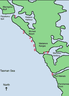 |
KEY:
Potential Marine Reserve Areas
1. Waionui Inlet and Papakanui Spit
2. Oaia Island and Muriwai Beach
3. Maori Bay Coast
4. Te Waharoa Coast
5. Anawhata Coast
6. Piha Coast
7. Destruction Gully Coast
8. Lawry Point Coast and Big Muddy Creek
9. Port Waikato Estuary
|
WHAT ARE THE THREATS TO THE AUCKLAND WEST COAST?
Threats are interrelated and hence their impacts on our ecological values may also have negative repercussions to all other values- economic, social, cultural and historical.
Possible management options to the threats outlined in Table 5 below are defined in summary format only. Table 6 (pages 23-25) covers the management options in more detail.
Table 5. Values to protect on Auckland’s Wild West Coast, their threats and management (current and potential)
| TO PROTECT |
THREATS |
MANAGEMENT (Current and potential) |
| Maui’s dolphin (formerly known as North Island Hector’s dolphin) |
- Commercial and recreational set nets: Maui’s dolphins have lungs so when caught in a set net may drown if it is unable to break free.
- Trawlers: whilst there are strong rumours there is still no definite evidence that Maui’s are caught by trawlers. However, numbers are too few to wait for an incident before giving them greater protection.
- Pollution: there is growing evidence that dioxins may harm Maui’s dolphin fertility. These dolphins are at greater risk to pollution due to their preference for shallow waters.
|
- Ministry of Fisheries commercial and recreational set net ban along the West Coast will protect Maui’s dolphin from capture in set nets. We need observers on trawlers.
- A Marine Park may limit commercial fishing within the park boundary and set regulations controlling pollution.
- Conservation areas on land may help buffer the ocean from pollution.
- A Marine Mammal Sanctuary may increase the status of Maui’s dolphin and further protect it against harmful fishing methods and pollution.
|
| General habitat and ecosystems (Includes all native flora and fauna, both marine and terrestrial, and their associated habitats) |
- Intertidal overharvesting: shellfish overharvesting is an increasing problem on many of the Intertidal rock platforms on West Coast beaches. New cultures to New Zealand often value many different types of organisms for food, which is placing greater pressures on these ecosystems
|
- There is a voluntary shellfish ban at some of the West Coast beaches, which has been placed by the local community and does not have any legal backing.
- Ministry of Fisheries has enforceable shellfish harvesting regulations. These include size, number, method of catch and with some shellfish certain seasons for taking. Infringement fines are enforceable if these fishing rules are broken.
- Marine Reserves may be used to protect the intertidal area from Mean High Water Springs to 12 nautical miles offshore (currently the boundaries for marine reserves are being considered in parliament for extension under the new Marine Reserves Bill).
- There are also a number of Maori fisheries management tools such as Taiapure, Maitaitai and Rahui, which may be used to protect the intertidal areas.
|
| |
- Visitor impacts: Visitors to the West Coast increase annually and with this comes an increase in pressure on the natural environment. More people fishing, walking on rock platforms, bringing potential litter to our beaches etc.
|
- Council coastal plans are in place to plan, control and monitor visitor impacts to the coastal environment. These plans are developed to ensure that infrastructure is in place to cope with increases in visitors.
- A Marine Park would raise the profile of the West Coast and encourage better measures to deal with increasing visitors. Marine education and advocacy will encourage visitors and the community to protect the environment they are visiting.
- A Marine Reserve will encourage education on how to care for the marine environment and as no-take areas will increase fish stocks.
- Sensitive areas may be designated Conservation Zones which restrict the type of activities that may be undertaken e.g. restricting off-road vehicles could protect areas such as Papakanui spit.
|
| |
- Overharvesting of subtidal areas: between commercial fishing quotas and recreational fishing catches there are a great number of fish being taken from the West Coast every year. Increase in population may also mean greater increases in the number of fish taken.
|
- Ministry of Fisheries control commercial fish catches under a Quota Management System, permits for non-quota species, fish size, gear restrictions and closed seasons for some species. There is still a large amount of bycatch, which is wasted and undetected. The Ministry sets bag limits and size limits on recreational fish catches with infringement fees and penalties. Policing is an ongoing problem in trying to enforce these regulations.
- A Marine Reserve would allow certain areas of the West Coast to be set aside as ‘no-take’ for fish to breed and as a safe haven for juveniles. There is worldwide evidence that shows marine reserves significantly increase fish stocks.
- More Honorary Rangers would aid in the policing problems on the West Coast.
- Areas put aside as Taiapure, Maitaitai and Rahui (Maori fishery management tools) may also aid in protecting marine life.
|
| |
- Pollution: e.g. sediment runoff from land, litter on beaches, litter dumped at sea, stormwater runoff, sewage etc.
|
- Council plans should control development, monitor impacts and prevent pollution coming from the land to the sea.
- Conservation areas along the coastline would act as a buffer to filter runoff.
- A Marine Park advisory board would advocate for the up grading of infrastructure to cope with increasing sewage and stormwater runoff.
|
| |
- Uncontrolled domestic animals (e.g. dogs and cats)
|
- Council bylaws already exist to control dogs on beaches. The problem with these existing laws is policing.
- The Department of Conservation is considering Dog control areas, which may help to protect wildlife from dogs.
- Within a Marine Park regulations should control domestic animals and support community initiatives. Through raising the profile of the area a Marine Park will encourage greater adherence to such regulations and encourage the community to take greater responsibility in caring for the environment.
- Education, through community awareness programs, pamphlets and signs is required.
- Conservation areas may also restrict people from taking their domestic animals into areas designated as sensitive.
|
| |
- Pests (e.g. marine invaders, weeds, stoats etc)
|
- Greater biosecurity awareness is required to prevent the introduction on new pests and the community needs to be kept up to date and be educated to identify any new pests requiring eradication. This could be achieved through educational signs, workshops, pamphlets etc.
- A Marine Park could be the catalyst to a whole host of educational mediums to educate the public.
~ Councils are already involved in distributing information and getting community groups to eradicate pests.
- Conservation areas along the coastline with intensive pest control are required.
|
POTENTIAL MANAGEMENT OPTIONS FOR AUCKLAND’S WEST COAST
Table 6 below and on pages 18-19, lists some of the potential management options for Auckland’s Wild West Coast. It is intended to be a summary only, so as the reader can refer to these options when considering potential management models for the coast.
Table 6. Potential management options for Auckland’s Wild West Coast
| Management Option |
Description |
QMS
(Quota Management System)
*NB: already operating |
- Introduced 1986 to prevent overfishing and improve economic efficiency of fishing industry.
- Controls total commercial catch from all main fish stocks found within New Zealand’s 200nm EEZ.
- QMS is an ‘output control’ which means it directly limits total quantity taken by the commercial fishing industry.
- Every year the government decides what quantity of quota species may be caught, based on information provided by scientists at M-Fish and other interest groups such as the commercial fishing industry, Maori, conservation groups.
- Scientists provide data on size and productivity of the resource using the concept of Maximum Sustainable Yield (MSY), which is the largest annual catch that can be taken over time without reducing stocks productive potential.
- The total amount of stock that can be taken by both commercial and non-commercial fishers is termed the Total Allowable Catch (TAC)
- From the TAC an allowance is made for Maori (government responsibility to ensure 20% of all commercial quota is transferred to the Treaty of Waitangi Fisheries Commission) and non-commercial fishers and the remainder is the allowance for the commercial industry termed the Total Allowable Commercial Catch (TACC)
- TACC is further divided into Individual Transferable Quota (ITQ), which commercial fishers can fish, sell or lease.
- Fishers can spread their catching programme throughout the year and if they catch fish they do not have quota for (by catch) they can buy quota to cover or if not catching all of their quota they can sell, or lease part of it.
|
| Permitting |
- Species not on the QMS e.g. Tuna are controlled by permits. Permits are issued to allow commercial fishers to take certain species by defined methods
|
| Closed seasons |
- Time closures to protect fish stocks by reducing opportunities people have to fish for them.
- Closures may exist during species breeding periods in other cases, e.g scallops, fishing period is open during breeding season to allow harvesting when they are in their peak condition
|
| Size limits |
- Size limits are imposed on most species e.g blue cod must be at least 30cm long, trevally and snapper 25cm long, so that juveniles have a chance to breed at least once in their lifecycle
|
| Gear restrictions |
- E.g. size of mesh nets
- How nets are used e.g. flounder/ mullet nets must not be set across a waterway.
|
| Marine Reserves |
- A marine reserve is an area of the sea where habitat and all biota are completely protected. Currently marine reserves are created for scientific study however, there is currently a new Marine Reserves Bill aiming to broaden the reason behind their set up. Among other things, the new Bill will also provide greater guidance as to the way treaty obligations should be met and will allocate a specified time frame to the decision making process for marine reserve applications.
- Marine Reserves can be set up under the Marine Reserves Act 1971. The minister of Conservation receives applications and makes the final decision however, the Ministers of Transport and Fisheries have to agree with that decision. This is also currently under review with the new Marine Reeves Bill.
- Extensive consultation with the public is essential before and during the application process.
- Most extractive activities such as fishing and marine farming are prohibited in Marine Reserves.
|
| Taiapure |
- A taiapure is an estuarine or littoral coastal area, which is traditionally important to Iwi or hapu. A taiapure protects these local areas and recognises that local communities have special needs relating to them.
- Applications for taiapure are made to the Minister of Fisheries under the Fisheries Act 1996. The minister if Fisheries makes his/her decision in consultation with the Minister of Maori Affairs.
- Anyone can apply for a taiapure and the proposal must show that the area is important to the local Iwi or hapu for kaimoana, spiritual or cultural reasons.
- Taiapure’s are managed by a committee of people nominated by and representative of the local Maori community as formed by the minister of Fisheries. The committee recommends regulations to M-Fish to manage the area. The local community and MAF administer regulations.
- Commercial and or recreational fishing may be allowed, however rahui may be applied to stop all or some fishing to allow for restoration.
- Extensive consultation with the public is essential before and during the application process
|
| Maitaitai |
- Maitaitai reserves are areas of traditional importance to Maori where the tangata whenua are authorised by M-Fish to manage and control the harvest of seafood for non-commercial purposes. Kaitiaki, appointed by the local Maori community can manage this area by passing bylaws.
- Controls on non-commercial fishing within maitaitai reserves must apply equally to all people with only one exception, if a reserve is closed for general harvesting, the kaitiaki may approve the taking of seafood to meet the needs of the marae belonging to the tangata whenua of the reserve only.
- By laws may include: species that can be taken, quantity of each species, size limits, method of catch, area where taken and any other specifications made by the Kaitiaki necessary for the sustainable management of fisheries resources
|
| Rahui |
- Rahui is a non-statutory, total ban on fishing applied to certain species; it may only be initiated by Tangata Whenua. The time frame is open ended and determined by Tangata Whenua. E.g Karekare shellfish ban set in 1993 still exists today.
- Rahui may be applied within a taiapure or maitaitai – local fishery.
- The statutory support comes from the Fisheries Amendment Act 1998, and is part of the Fisheries Act 1996 (the principal Act), section 186a. This amended section allows for temporary closures of fishing areas or restrictions on fishing methods (maximum of 2 years after notification in the Gazette). Section 297 and 298 under Part 16 of the Fisheries Act 1996 allows for regulatory closures, which are open ended. Currently the long-term rahui at KareKare beach is supported by a regulatory closure.
|
| Marine Park |
- There is no existing legislation to make Marine Parks – new legislation must be created
- A marine park is an area recognised as having significant conservation values and warranting greater protection. The management of such an area is achieved by outlining objectives for protection and adopting policies, which address these. Such an area may be made up of a variety of different management levels such as sections of no take (Marine Reserves) and also sections where fishing is permitted.
- Marine Parks are not completely, no-take areas.
|
| Marine Mammal sanctuary |
- Section 22 of the NZ Marine Mammal Protection Act (1978) provides, at the discretion of the Minister, for the establishment of Marine Mammal Sanctuaries, within which fishing activities may be restricted.
- Marine mammal sanctuaries can not be declared in any Maritime or National Park, in any reserve with the meaning of the Reserves Act 1977, or in any marine reserve declared under the Marine Reserves Act 1971.
- Policing - all rangers and constables appointed under section 38 of the Wildlife Act 1953[Section 40 of the National Parks Act 1980], or under section 8 of the Reserves Act 1977 shall have the authority to exercise any of the powers conferred on a ranger under section 39 of the Wildlife Act 1953 in any Marine Mammal Sanctuary.
- E.g. Banks Peninsula
- Provisions are made for restrictions on fishing etc within the sanctuary
|
| Territorial Authorities |
- Planning & development control documents
- Bylaws
|
| Department of Conservation |
Discussion document (Sep 2002) on controlled and open dog areas |
INTEGRATED MANAGEMENT PLAN FOR AUCKLAND’S WILD WEST COAST
The integrated marine management plan for Auckland’s West coast is made up of 5 main elements (A – E, pages 26-29), including a marine park, marine mammal sanctuary, marine reserve network, Maori fishery management tools and shoreline and hinterland conservation areas.
A. Marine Park
The integrated concept for the west coast is to establish a marine park with a number of different zones within it. The establishment of a marine park will require special legislation. This may be a timely process and hence other elements making up the park, such as a marine reserve network and a marine mammal sanctuary may be progressed separately. Legislation already exists to develop these latter elements. Examples of Marine Parks in New Zealand include the Hauraki Gulf Marine Park and the Sugar Loaf Islands Marine Park. International examples include the Greater Barrier Reef Marine Park, Australia and Solitary Islands Marine Park, Australia.
Why?
The West Coast Working Group along with many local residents and community members believe that a Marine Park is needed on the Auckland West coast to better coordinate the management of the marine environment and foreshore. The objective of the marine park would be to protect representative examples of marine bio-diversity, while catering for a range of recreational activities. A Marine Park would establish an advisory/management board made up of a number of representatives from stakeholder and community groups. The responsibilities of this board would include advocacy, education and the co-ordination of management objectives within the marine park area. A marine park advisory board may achieve greater marine management by working alongside local bodies and statutory authorities. In theory the Marine Park may be thought of as a legislative ‘tool box’ in which all other legislation is used and monitored (see appendix for the proposed draft marine park legislation).
What you can do
A Marine Park would have a number of different zones within it. Some of these zones may allow for marine reserves whilst others will allow for recreational fishing. Activities that may be enjoyed in a Marine Park include:
- Coastal walks,
- Picnics,
- Recreational line fishing and drag netting (primarily for mullet and flounder at Muriwai and Karioitahi beaches) within the general amateur fishing regulations or specific, local restrictions as may apply,
- Surfing,
- Swimming,
- Rock pool observation and nature study activities,
- Bird watching,
- Boating and sailing,
- Underwater diving (with local restrictions).
What you can not do
Activities that may be prohibited in the marine park include:
- Commercial fishing,
- Recreational set netting,
- The discharge of wastes,
- Construction of any structure unless specifically approved,
- Dredging,
- Inappropriate use of vessels
B. Marine Mammal Sanctuary
The Department of Conservation administers the Marine Mammals Protection Act 1978, which provides for the conservation, protection and management of marine mammals. This Act allows for the establishment of marine mammal sanctuaries. Activities can be controlled by specifying what can and cannot be undertaken within the sanctuary and by imposing restrictions. Examples of marine mammal sanctuaries within New Zealand include the Banks Peninsula marine mammal sanctuary (to protect Hector’s dolphin) and the Auckland Island’s marine mammal sanctuary (to protect NZ sea lion and southern right whale).
Why?
The world’s smallest and rarest marine dolphin is found only off this coast. Maui’s dolphin has been recognised as a separate subspecies from other Hectors dolphin populations in New Zealand. This special population off Auckland’s west coast is made up of less then 100 individuals, which means that it is in a critical state. A marine mammal sanctuary would give greater status to Maui’s dolphin and help to further protect it from habitat destruction, pollution and harmful fishing methods. Increasingly New Zealand fur seals are also being seen off this coast. Fur seals would also benefit from greater protection on this coast.
What you can do
Activities that may be enjoyed in a marine mammal sanctuary include:
- Coastal walks
- Picnics
- Recreational line fishing and drag netting (primarily for mullet and flounder at Muriwai and Karioitahi beaches) within the general amateur fishing regulations or specific local restrictions as may apply
- Surfing
- Swimming
- Rock pool observation and nature study activities
- Bird watching
- Boating and sailing
- Underwater diving (with restrictions)
What you can not do
Activities that may be prohibited within a marine mammal sanctuary Include:
- Commercial fishing
- The discharge of wastes
- Inappropriate use of vessels
C. Marine Reserve Network
Marine reserves may be set up under the Marine Reserves Act 1971 and are administered by the Department of Conservation. Marine reserves protect areas of the sea, seabed and foreshore in a natural state for the purpose of scientific study. Marine habitats, plants and animals are all protected within marine reserves. These areas are usually completely ‘no-take’. Examples of marine reserves in New Zealand include Cape Rodney – Okakari Point Marine Reserve, Long Bay – Okura Marine Reserve and Kermadec Islands Marine Reserve.
Why?
The intertidal organisms of many of the more accessible places on the Auckland west coast have been, and continue to be overharvested. Subtidally fish are taken by recreational and commercial fishing. Scientists believe that 80% of New Zealand’s bio-diversity remains undiscovered in our oceans. For these reasons it is important that we create ‘safe havens’ or ‘refuges’ for our marine life. Studies from around the world of 100 no-take marine reserves have shown an average increase of 91% in the number of fish, 31% increase in the size of fish and 23% increase in the number of species within reserves. Spillover of fish may occur into the surrounding waters of marine reserves. Having a network of ‘no-take areas on the Auckland west coast will ensure that a representative collection of marine bio-diversity is protected on this coast and will add to the protection of New Zealand’s bio-diversity as a whole. They also allow for scientific research to be undertaken in the marine environment. Currently there are no marine reserves on the Auckland west coast.
What you can do
Marine reserves are open for the public to enjoy and study the marine environment. Activities that do not damage or disturb the marine life are allowed in marine reserves. Some of the activities enjoyed in marine reserves include:
- Boating
- Anchoring
- Picnicking
- Swimming
- Snorkelling
- Diving
- Nature studies
- Surfing
What you can not do
Generally, activities that damage or disturb the habitat and marine species are not allowed within Marine reserves. Commercial fishing is not allowed and usually recreational fishing and seafood gathering is not allowed either.
*NB: The Marine Reserves Act is currently being revised by Parliament.
D. Maori fishery management tools (taiapure, maitaitai rahui)
Taiapure: A taiapure is an estuarine or littoral coastal area, which is traditionally important to iwi or hapu. A taiapure protects these local areas and recognises that local communities have special needs relating to them.
Anyone may apply for a taiapure. The proposal must show that the area is important to the local iwi or hapu for kaimoana (seafood), or spiritual or cultural reasons. The Minister of Fisheries receives taiapure applications and makes his/her decision in consultation with the Minister of Maori Affairs. A special tribunal of the Maori land court hears any submissions or objections. If the Ministers declare that the area should become a taiapure, the Minister of Fisheries forms a management committee of people nominated by and representative of the local Maori community. The committee recommends regulations to the Minister of Fisheries to manage the area. The Ministry works with the committee to administer these regulations.
Commercial and/or recreational fishing may be allowed in a taiapure however, rahui may be applied to stop all or some fishing to allow restoration of these coastal fisheries or because the area is sacred to iwi or hapu.
Maitaitai: A maitaitai reserve is an area of traditional importance to Maori where the tangata whenua are authorised by the Ministry of Fisheries to manage and control the harvest of seafood for non-commercial purposes.
Kaitiaki, appointed by the local Maori community can manage this area by passing bylaws. Bylaws may include species that can be taken, quantity of each species, size limits, methods of catch, area where taken and any other specifications made by the kaitiaki necessary for the sustainable management of fisheries resources.
Controls on non-commercial fishing must apply equally to all people with only one exception. If a reserve is closed for general harvesting, the kaitiaki may approve the taking of seafood to meet the needs of the marae belonging to tangata whenua of the reserve only.
Rahui: Rahui is a ban on all or some fishing to allow restoration of coastal fisheries or because the area is sacred to iwi or hapu. Rahui may be applied to selected species and may only be initiated by tangata whenua. Rahui may be applied within a taiapure or maitaitai reserve.
The statutory support for a rahui comes from the Fisheries Amendment Act 1998, and is part of the Fisheries Act 1996 (the principal Act), section 186a. This amended section allows for temporary closures of fishing areas or restrictions on fishing methods (maximum of two years after notification in the Gazette). Section 297 and 298 under Part 16 of the Fisheries Act 1996 allows for regulatory closures, which are open ended. Currently the long-term rahui at Karekare beach on Auckland’s west coast is supported by a regulatory closure.
E. Shoreline and hinterland conservation areas
The surrounding shoreline and hinterland areas of the West coast require protection as well as the marine area below MHWS if we are to achieve a holistic ‘land to sea’ approach to environmental management.
Through the integrated management plan for the Auckland west coast private landowners will be invited to consider including part of their land as private conservation areas. Liaison with local and regional authorities to further protect public land will also be undertaken. Conservation areas may be established under the QEII National Trust or other covenant. Local and regional authorities may apply for reserve status for lands also under the Reserves Act 1977. For example the Whatipu sands area has recently been made into a scientific reserve by the Department of Conservation and will be administered by the Auckland Regional Council.
BOUNDARY OPTIONS (1 & 2)
Each boundary option is made up of exactly the same elements as outlined on pages 26-29 (A-E). The only difference between the two models is the size of the marine park and the size of the marine mammal sanctuary. The West Coast Working Group and Forest and Bird are seeking your comments on the entire concept of the integrated plan with each of the elements and also your preference for the different boundaries of the marine park and marine mammal sanctuary. See maps below.
BOUNDARY OPTION 1
Option 1: greater marine protection on Auckland’s West Coast
 |
KEY:
 |
Option 1
- Marine Park from Papakanui Spit in the North to Port Waikato in the South. Extends into the Manukau Harbour to a line drawn from Laingholm to Mako Point. Extends from Mean High Water Springs (MHWS) to 4nm seaward.
- Marine Mammal Sanctuary from Papakanui Spit in the North to Port Waikato in the South. Extends from MHWS to 4nm seaward. Extension into Manukau Harbour the same as the Marine Park boundary.
BOUNDARY OPTION 2
Option 2: greater marine protection on Auckland’s West Coast
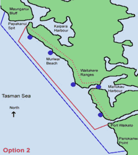 |
KEY:
|
Option 2a (with 4nm marine mammal sanctuary)
- Marine Park from Papakanui Spit in the North to Port Waikato in the South. Extends into the Manukau Harbour to a line drawn from Laingholm to Mako Point. Extends from Mean High Water Springs (MHWS) to 12nm seaward.
- Marine Mammal Sanctuary from Maunganui Bluff in the North to Pariokariwa Point. Extends from MHWS to 4nm seaward. Extension into Manukau Harbour the same as the Marine Park boundary. This entire area covers the current Ministry of Fisheries commercial set net ban area).
Option 2b (with 12nm marine mammal sanctuary)
- Marine Park from Papakanui Spit in the North to Port Waikato in the South. Extends into the Manukau Harbour to a line drawn from Laingholm to Mako Point. Extends from Mean High Water Springs (MHWS) to 4nm seaward.
- Marine Mammal Sanctuary from Maunganui Bluff in the North to Pariokariwa Point. Extends from MHWS to 12nm seaward. Extension into Manukau Harbour the same as the Marine Park boundary
REFERENCES CITED
Auckland Regional Council 1996, Regional Plan: Coastal, Environment Division, Auckland.
Auckland Regional Council 2000, Statistical Data on visitors to regional parks (Supplied by Neil Olsen)
Auckland Regional Parks Service STRATEGY draft, January 1996 (ARC – Auckland Regional Council) [Takapuna Library 719.32AUC]
Cameron, Hayward and Murdoch 1997, A Field Guide to Auckland: Exploring the Region’s Natural and Historic Heritage, Godwit Publishing.
Carton, A.G. April 1993, Human Impact on the behaviour and breeding success of gannets (Morus bassana serrator) at Muriwai, Prepared for the Auckland Regional Council Parks Service
Cometti and Morton 1985, ‘Margins of the sea: Exploring New Zealand’s Coastline’ Hodder and Stoughton, Auckland.
Denyer et al 1993, Waitakere Ecological District: Survey report for the protected natural areas programme; Programme No. 15, ARC, Newton Auckland.
Department of Conservation and Ministry for the Environment, The New Zealand Biodiversity Strategy: Our Chance to turn the tide, February 2000
Department of Conservation ‘Conservation Management Strategy’ 1995
Environmental Issues – People’s Views and Practices. A review and critique of environmental perception surveys, Environmental Waikato, Prepared by Nemec Montague Associates Ltd, August 1997 [Takapuna Library 333.720993NEM]
Environmental Planning & Management in New Zealand Ed. P. Ali Memon & Harvey Perkins, 2000 [Takapuna Library 333.70993ENV]
Gibbs. S, 2000, Kaipara a harbour that needs protection in Forest & Bird Magazine, ed. Gordon. E, Vol. 300: 96-100,
Harding et al, “The Intertidal Habitat of the Waitakere Coastline”, School of Biological Sciences, University of Auckland, June 2000.
Harvey. R.A 1998, Untamed Coast: Auckland’s Waitakere Ranges and West Coast beaches, Exisle Publishing Ltd, Auckland New Zealand
Hayward 1983, Geological Map of New Zealand, Waitakere, Sheet Q11 1:50,000, New Zealand Geological Survey, Department of Scientific and Industrial Research, Lower Hutt.
Hayward & Diamond 1978, ‘Prehistoric Archaeological sites of the Waitakere Ranges and West Auckland, New Zealand, ARA.
Hayward & Morley (in press), “Intertidal life around the coast of the Waitakere Ranges, Auckland’ Prepared for Auckland Regional Council (ARC).
Hume et al, NIWA Client Report, “Piha Beach: Coastal physical processes, effects of human activities and future management”, July 1999.
Hutching 1998, ‘The natural world of New Zealand: An illustrated encyclopaedia of New Zealand’s natural heritage’ Penguin Books (NZ) Ltd.
ICUN The World Conservation Union, Parks: Protected Area Programme, Marine Protected Areas, June 1998, Vol 8 No. 2, Gland, Switzerland.
Learning to Care for Our Environment “A National Strategy for Environmental Education”. Ministry for the Environment, June 1998 [Takapuna Library 333.7071LEA]
Local Government Environmental Management. ‘At study of models and outcomes’, Parliamentary Commissioner For the Environment, Controller and Auditor – General [Takapuna Library 333.70993LOC]
Maori Participation in environmental mediation, Carolyn Blackford, Hiriri Matunga, August 1991, Information Paper No.30 [Takapuna Library 333.720993BLA]
McDermott Fairgray 2000, ‘The Tourism Effect: Impact on the Auckland Region Economy’, prepared for Auckland City Council.
Ministry for the Environment, Environmental Performance Indicators: Summary of the proposal indicators for the Marine Environment, November 1998, Ministry for the Environment, Wellington, New Zealand.
Morton et al 1993, ‘A Natural History of Auckland’ Golden Heights Publishing, Auckland.
Murdoch Graeme M.A (Hons), Historian, “The Whatipu Sands”, An Historical Background Report, ARA Regional Planning Department, September 1989.
Muriwai Regional Park Draft Management Plan, Auckland Regional Authority, Regional Parks Department, April 1989 [Takapuna Library 719.32AUC]
National Parks and other Wild Places of New Zealand, Kathy Ombler, 2001 [Takapuna Library 919.30MB]
New Zealand Conservation Authority 1997 ‘Maori Customary use of native birds, plants and other traditional materials: Interim report & discussion paper, NZ Conservation Authority, Wellington.
Ornithological Society of New Zealand (OSNZ) unpublished information, June 2001
Russell, Kirsty, School of Biological Sciences, University of Auckland, “Distribution of Public Sightings of Hector’s Dolphins in North Island Coastal Waters, June 2002.
Understanding the conservation expectations of Aucklanders, Department Of Conservation. April 2001 [Takapuna Library 333.7209932 JAM]
Waitakere City Council, August 1993, Waitakere City Environmental Issues: Background Paper 1, The Coast, Strategy and Development Unit, Waitakere City Council, Henderson.
West Community & Waitakere City Council 2001 ‘The West Coast Plan: A plan for future management of the West Coast and Waitakere Ranges
|