| Management
of Scallops in New Zealand
To achieve a good level
of understanding of complex fisheries management scenarios we believe
it is important to read the available data in good order.
The various documents
have been broken up and reorganised by each scallop fishery. This
facilitates downloading as, intact, these documents are often big
and unwieldy.
For each fishery management
proposal we have submitted to, we present the available information
and our submission alongside others views.
- The Ministry of Fisheries (MFish) management proposal as presented
in the Initial Position Papers (IPPs).
- The Minister of Fisheries' "Preliminary View" letter,
if published.
- Submissions to the IPP from option4 and others, as available.
- The MFish Final Advice Paper (FAP) incorporating stakeholders
submissions.
- The Minister's Final Decision for the species.
- Articles and Letters relating to this fishery, as available.
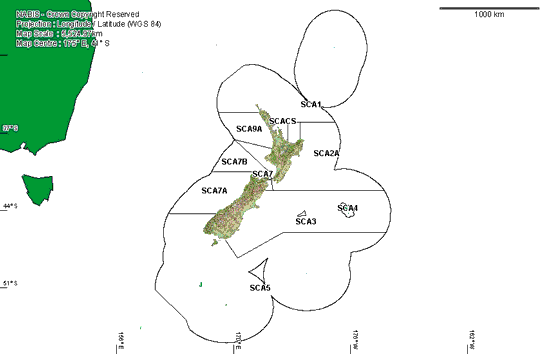
Scallop
Areas
New Zealand is divided
into thirteen areas for the management of scallops.
Location of
boundaries of the scallop (SCA) Quota Management Areas.
|
| This map has been sourced from www.nabis.govt.nz
|
At the moment we have
documents online that relate to:
| SCA1 - Northland, northeast coast down to Bream Tail |
|
| SCA CS - Coromandel, Bream Tail to Bay of Plenty |
|
|