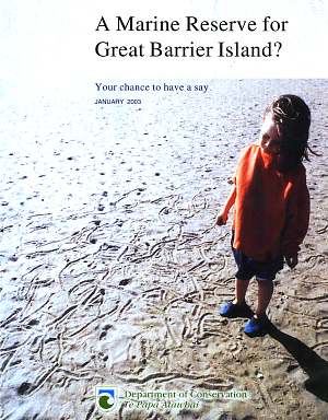
A Marine Reserve for Great Barrier Island?
Your chance to have a say
January 2003
Marine reserve proposal by the Department of Conservation.
This document contains all the text of the original
proposal as printed on a 16-page glossy brochure. The text in blue was
provided by us to illustrate or rebut statements. The original PDF document
can be found here
on the DoC web site (577KB+form). Recent images of the underwater world
(June 2003) have been added.
Marine Reserve status: Proposal
stage.
Closing date for objections was 30 June 2003 but has been
extended to 31 July 2003
. Click here to support/object. |
A legacy for our children
The seas around Great Barrier Island are some of the most pristine
in the Hauraki Gulf, with a remarkable variety of underwater landscapes
and marine life. However, even here, locals are reporting that fish aren't
as plentiful as they used to be. A marine reserve will ensure that at least
one part of Great Barrier's marine world is protected and replenished to
pass on to our children and grandchildren. |
Unfortunately, this area is no longer
able to replenish itself since it is degrading rapidly. Yet this was not
caused by fishing. It makes no longer sense to have a marine reserve here
because the main problem of our coastal seas, which is also manifest here,
is the devastating influence of land-based pollution. What is needed are
measures to increase the fish stocks throughout the Hauraki Gulf, and around
Great Barrier.
A decade of discussions
Over a decade ago , the Department of Conservation began talks with
tangata whenua and local residents about the need to protect Great Barrier
Island's coastal waters. Keen to establish a marine reserve somewhere around
this island, DOC circulated a public discussion paper and questionnaire
in February 1991. Over 250 people, mainly islanders, sent in their comments. |
This is a marine reserve proposal with
history. As part of the consultation process during the lead up to
the 1994 marine reserve application, a steering committee was formed at
a public meeting held at the Claris Sports Club. This committee was chaired
by John Graham and was made up of a cross section of the community, including
representatives from the South, Central and North Barrier communities,
professional and recreational fishermen, non-fishermen, at least one DoC
worker. This group eventually recommended that there was local support
for a small marine reserve as shown with the red solid lines on the map,
corresponding to the 1991 proposal. There was no support for any reserve
larger than that.
This early feedback expressed both concern over the decline in the island's
fisheries, and strong support for a fully protected marine reserve on the
island. The north-east coast was the favoured location for 75% of the people
who wrote in. Most respondents (65%) claimed that a marine reserve would
not cause problems for their current activities in the area. However, three
percent were totally opposed to any marine reserve. Restrictions on fishing
were the key concern.
Time and again, DOC quotes strong support,
whereas this was not so. For instance, at the Great Barrier Community Board
meeting of 31 May 2003 the proposal was voted down almost unanimously but
this was reported by DOC as: the vote at the meeting that was held on
GBI at the weekend was for the proposal as it currently stands. Indeed
the vote was about the current proposal. It is sad that we can no longer
trust our Government which is employing war techniques of propaganda, disinformation
and division.
Note the precise wording in the questionnaire:
Do
you support the principle of a marine reserve somewhere on the north-east
coast of Great Barrier Island? Yes/No. What are people supposed to
answer when they are against the present proposal but not against a small
reserve somewhere else? The first and foremost question should have been:
Do
you support this proposal? Yes/No.
New discoveries
Earlier discussions about possible boundaries for a marine reserve
centred on an area including the Whangapoua Estuary and beach, the coastline
immediately north and south of Whangapoua and the seas out to and surrounding
Rakitu Island.
In the years since, DOC has been carrying out further marine studies
in an area extending from Needles Point in the north to Korotiti Bay in
the south, and a large area offshore. |
Since the earlier marine reserve proposals were discussed, our knowledge
about marine environments and what is needed to best protect them has expanded.
Scientists now think that larger marine reserves may be more effective
because a larger range of habitats are protected and the effect of fishing
at the reserve edges is reduced.
Having had overwhelming adverse reaction
from the public, fishing industry, tangata whenua and community, DOC could
not come back with the same proposal. But it is true that larger marine
reserves are more effective at protecting more species and habitats. However,
marine reserves do not protect against land-based pollution and poisonous
plankton blooms. The entire proposed area has been devastated by this.
In 1993 the whole kelp forest disappeared, as did most sponges and other
sessile filterfeeders and schooling fish. Recently in 2002 this happened
again, but more devastating for sponges than for kelp. Many fish species
also disappeared. Read Seafriends' study of this phenomenon www.seafriends.org.nz/enviro/habitat/survey93.htm.
The most exciting discoveries were made in 2002, when a team of scientists
and locals sent a remotely operated camera down to 100 metre depths north
east of Rakitu. This area, shown as only slightly raised seafloor on the
marine charts, revealed a remarkable undersea world - deep water reefs
hosting coloured sponges, black coral colonies, jewel anemones - and kingfish.
DOC produced a movie from which the image on
the right was taken. The best scenes of the deep water survey by remotely
controlled camera were shown in this movie. Yet these could not hide the
overwhelming amount of mud covering the sea bottom, smothering organisms.
The organisms showed known signs of stress such as the absence of juveniles.
The large organisms in this movie have a story to tell, about how good
conditions once were but no longer are. This whole area will deteriorate
further with time, even when completely protected.
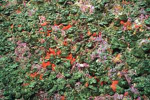
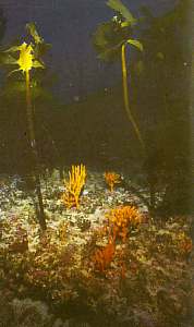
On this image one can see a dead black
coral tree in the background, covered by hardy purple jewel anemones. The
base of this tree shows that it was once a large one. |
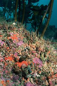
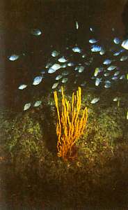
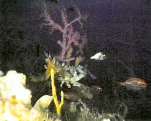 Black coral colonies, sponges and a wealth of invertebrate
life on a deep reef north of Rakitu. |
Why a marine reserve?
Marine reserves are the 'national parks' of the sea, where underwater
features and marine life enjoy complete protection. Their purpose is to
protect representative, unique or special marine habitats for scientific
study and enjoyment. |
One cannot compare marine reserves with
national parks. Our national parks are tracts of land which cannot be lived
on or harvested because they are unproductive. On the other hand, the sea
is entirely productive everywhere and can be accessed with ease. The national
parks are not threatened by muddy sediment but the sea is.
Because much of our underwater environment has been altered by human activities
we need to protect bits that represent samples of what was originally there.
Within a reserve, marine life is left to recover and flourish in its natural
state - for its own sake and for future generations. As with national parks,
people are encouraged to visit, marvel at and learn from marine reserves.
Not true. The underwater environment
is the least altered environment of all. Its kelp forests have not been
burnt for agriculture; nobody is living there; the seabottom has not been
paved with roads; there are no invasive species like cats, rats, stoats,
goats, deer, rabbits, possums. By far most of the marine life will not
improve inside a marine reserve but some fished species will to some extent.
Most Great Barrier Island locals know that the island's seas aren't as
bountiful now as they were in 'the old days'. A marine reserve will help
restore the balance and protect the marine taonga of part of Great Barrier's
coast for the benefit of present and future generations.
Speculation. Locals have worked hard
to protect their coasts with better means than marine reserves. In 1992
they achieved a 1 mile commercial set net ban right around the Great
Barrier and the Mokohinau Islands, with spectacular results. Where was
DoC when they needed them? A marine reserve will do nothing to the areas
outside and it will not address the causes of our problems.
Imagine how our fisheries could look if the option4
Principle #3 of a Planning Right was enforced. It would empower the public
to leave fish in the water, secure in the knowledge that those fish would
not simply be reallocated to the fishing industry driven by insatiable
export markets.
|
Why is the NE coast of Great
Barrier Island not what it could have been?
The green girdle of islands located
outside the coast of the mainland stretches from White Island to the Poor
Knights, including Great Barrier Island. Visit White Island or the Poor
Knights, and one experiences clear water supporting a profusion of biodiversity
under water. Obviously, the distance away from our polluting shores plays
an important factor. But why is Great Barrier not like the other, much
smaller islands?
Firstly, it encloses the Hauraki
Gulf which fills with run-off from the mainland including that from the
heavily polluted Waihou river. This runoff fertilises the plant plankton,
resulting in dense plankton blooms and a severe reduction in underwater
visibility. The over enriched waters of the Gulf have only two ways to
escape: on the south through the Colville Channel and then along the Coromandel
coast towards the Mercuries, and on the north through the Craddock Channel,
around the Needles to the east coast of the Barrier. Secondly, the Barrier
still has much barren eroding soils, a legacy from Kauri logging and poor
land management. It should be no surprise then that the proposed area suffers
from serious degradation. But what evidence exists?
The Auckland University Field trip
to Rakitu in the Christmas holidays of 1980/81 experienced such dark brown
plankton blooms (visibility 0.5-1m) that underwater surveys were not possible.
[Tane Vol 28, 1982. Little Barrier Island, Rakitu Island]
First in 1992 and again in 1993
the entire kelp forest (80-100%) deeper than 12m disappeared from the entire
area, and with it sponges, bryozoa, seasquirts and more. This also happened
in an arch around the outer Hauraki Gulf from Leigh to the Hen and Chicks.
Pelagic fish species also considerably reduced in numbers. [www.seafriends.org.nz/enviro/habitat/survey93.htm,
Floor Anthoni, 1993]
Between October and December 2002
another major kill of vertebrate species (fish) and invertebrates happened,
resulting in the almost complete loss (95-100%) of sponges and other filterfeeders
and to a lesser extent grazers such as urchins and snails. [to be published,
Floor Anthoni]
It is sad that scientists and DoC
remain uninformed about the seriousness of the situation, even though it
is there for all to see. Why have no surveys been done since 1990? The
two most devastating events happening since, have not been noticed! Obviously,
a marine reserve will not 'revert this environment to what it once was',
as repeatedly claimed by DoC and others. IT WILL NOT WORK!
Dr Floor Anthoni, June 2003 |
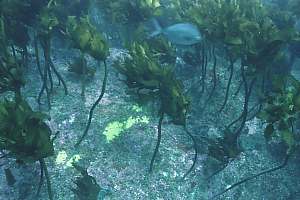 f036801: The kelp forest is open, letting
sunlight through to the rocky bottom. Barren patches show where large sponges
once stood. There is little kelp recruitment. The older kelp is mainly
of one age group, an indication of stress.
f036801: The kelp forest is open, letting
sunlight through to the rocky bottom. Barren patches show where large sponges
once stood. There is little kelp recruitment. The older kelp is mainly
of one age group, an indication of stress. |
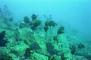 f036804: A little deeper, particularly
where shelter is found, the kelp forest opens up completely, while all
the rock is covered in sticky dust. There's nobody home. The kelp forest
does not recover. (Depth 15m)
f036804: A little deeper, particularly
where shelter is found, the kelp forest opens up completely, while all
the rock is covered in sticky dust. There's nobody home. The kelp forest
does not recover. (Depth 15m) |
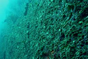 f036813: This vertical wall was once
covered in lush rock dwelling colonies of animals like colourful sponges,
anemones, bryozoa and hydrozoa.
f036813: This vertical wall was once
covered in lush rock dwelling colonies of animals like colourful sponges,
anemones, bryozoa and hydrozoa. |
 f036814: This is a closeup of the wall
on left. Successive ecological disasters have cleared the rock, allowing
a small seaweed to colonise it.
f036814: This is a closeup of the wall
on left. Successive ecological disasters have cleared the rock, allowing
a small seaweed to colonise it. |
 f036827: Remnants can be found of what
once lived on the vertical wall, but everything is covered in a sticky
mud.
f036827: Remnants can be found of what
once lived on the vertical wall, but everything is covered in a sticky
mud. |
 f036819: On a ledge a number of surviving
sponges attempts to recover from near-death, but all are covered
in sticky dust.
f036819: On a ledge a number of surviving
sponges attempts to recover from near-death, but all are covered
in sticky dust. |
 f036734: Behind a rocky outcrop the
cleansing action from waves can be seen. In the top right, the sessile
organisms are all clean, as is the large grey sponge. But lower down, three
grey sponges are dying because of being suffocated by sticky dust. Most
organisms occur in an advanced state of stress.
f036734: Behind a rocky outcrop the
cleansing action from waves can be seen. In the top right, the sessile
organisms are all clean, as is the large grey sponge. But lower down, three
grey sponges are dying because of being suffocated by sticky dust. Most
organisms occur in an advanced state of stress. |
 f036735: another image showing how
orange stick bryozoa are just able to survive high up the rock in the current
produced by waves. But lower down organisms are dying as they have been
choked by sticky dust. Over time this rock will be as barren as the others.
f036735: another image showing how
orange stick bryozoa are just able to survive high up the rock in the current
produced by waves. But lower down organisms are dying as they have been
choked by sticky dust. Over time this rock will be as barren as the others. |
A network of marine protected areas
 The
Government committed, in the New Zealand Biodiversity Strategy
(2000), to protect 10% of New Zealand's marine environment to
help conserve marine biodiversity. A network of marine protected
areas, which together protect a range of unique and diverse
habitats and ecosystems, will contribute to this target. it
may also enable marine species to move between protected areas
- a series of safe havens within movement range of adults or
juveniles. The
Government committed, in the New Zealand Biodiversity Strategy
(2000), to protect 10% of New Zealand's marine environment to
help conserve marine biodiversity. A network of marine protected
areas, which together protect a range of unique and diverse
habitats and ecosystems, will contribute to this target. it
may also enable marine species to move between protected areas
- a series of safe havens within movement range of adults or
juveniles.
The Government's policy is flawed. Marine
reserves do very little for marine biodiversity. For the non-fished species
they have no benefit, neither for the fished migratory species as they
move in and out of reserves. Only for fished resident species will they
be of benefit but these can be protected in other ways. The network idea
lives only in the minds of protagonists and has no ecological foundation
or scientific proof. Marine species moving between protected areas will
be caught just like those who live there permanently. There exists no scientific
proof that marine reserves are of benefit by their contribution of juveniles.
|
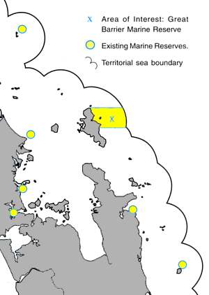
So far just 0.1% of the coast around mainland New Zealand is protected
within 15 marine reserves. There are three small marine reserves in the
Auckland region: Cape Rodney to Okakari Point (near Leigh), Long Bay to
Okura and Motu Manawa (Pollen Island) in the Waitemata Harbour. Another
- Te Matuku Bay on Waiheke Island - is awaiting approval from the Minister
of Fisheries.
Further north is the larger Poor Knights Islands marine reserve, and
to the south Te Whanganui-a-Hei (Cathedral Cove) on the Coromandel Peninsula,
and Mayor Island (Tuhua) marine reserves. It's the beginning of a network
that would be greatly enhanced by a marine reserve on Great Barrier's north-east
coast.
What are the benefits?
A marine reserve would help us to retain, in a natural and healthy
state, the great variety of plants and animals that live in the diverse
marine habitats found on the north-east coast of Great Barrier Island.
False. The marine reserve does not protect
against degradation, which is a major problem in the proposed area.
|
Marine reserves:
-
Help safeguard against environmental degradation and provide a benchmark
against which to measure human impacts in other areas. False.
They do not protect against degradation, as shown by over 2/3 of
our existing coastal marine reserves including Goat Island. Yes, they can
be used as a benchmark but it would be much better if scientists started
studying degradation, for which there exist no benchmarks: it happens everywhere.
-
Help rebuild depleted stocks of snapper, crayfish and other species, restore
kelp forests and the health of marine ecosystems. There
are better ways to do this, like fisheries regulation. The health of the
marine ecosystem is in serious decline.
-
Increase the range of fish types, as rare and more vulnerable species flourish
in the marine reserve. Rare species belong to areas
where they breed. They will continue to be rare, with or without a marine
reserve.
-
Protect the many marine processes and species we don't yet know about.
False.
These are just as much affected by degradation as others.
-
Act as a breeding area and reservoir for depleted marine species and provide
a source of larvae to boost populations inside and outside the marine reserve.
A
nice idea, but without scientific proof. Name some of the species that
will benefit. Mature snapper move out of this area into the warm Hauraki
Gulf to spawn.
-
Protect large, old experienced animals which may have important genetic
and social values not protected under fisheries rules. This
is indeed what a reserve does well, but there are other ways for achieving
this - a closed area for trawling and maximum size restrictions for instance.
But its value should not be overstated, since even at the Poor Knights
such large, old animals have not appeared.
-
Allow fish and marine life to be observed in their natural habitat, natural
sizes and numbers and exhibiting natural behaviour. There
is no objection against marine reserves in hotspots, attracting both fish
and divers. Point out on the map where such a hotspot is.
-
Provide a window on a beautiful and fascinating underwater world. Marine
reserves are ideal places for scientific study, education, snorkelling
and diving, underwater photography, swimming, exploring rock pools and
eco-tourism. Only when they do not degrade, have
clear water and easy access, will marine reserves be used by divers, underwater
photographers, eco-tourism and for education. It must be remembered that
the
best dive spots in Leigh are outside the marine reserve in an unprotected
sea.
Uses of the north-east coast
People undertake a range of activities on the north-east coast. Responses
to the 1991 questionnaire showed the most popular pastimes were swimming,
sightseeing, surfing, sunbathing and beach walking. Next were boating (including
sailing, windsurfing and water skiing) and recreational fishing. Other
activities were diving and snorkelling, education, scientific study, traditional
and commercial fishing and tramping. |
How would a marine reserve affect you?
The only activities that would be affected by a marine reserve in the
area are fishing, shellfish gathering and removal of shells. Taking any
marine life, including fishing and gathering shellfish, rocks or seaweed,
is not allowed in a marine reserve. However, fish caught outside a marine
reserve can be carried through the reserve. |
The problem of the Marine Reserves Act
is that it provides only one tool, permanent and total closure to extraction.
It is the wrong tool for this area where sustenance fishing is of major
importance. Not a word is mentioned about this in the proposal. A marine
reserve under the Fisheries Act however, would allow many degrees of flexibility
to produce the right solution for this area.
A marine reserve on the north-east coast may have economic and social implications
for commercial and recreational fishers in the area. However, fishing is
likely to improve in the areas near the reserve and, in the long term may
benefit stocks further afield. Visitors can take boats into marine reserves
and anchor but are encouraged to minimise disturbance to the sea floor.
The spill-over effect of a large marine
reserve like this is but a very small fraction (5%) of the lost fishery.
Although at the moment people have the right of 'free and innocent passage',
if fish is found on board, the onus of proof that the fish was caught outside,
will be on the fisherman and not on DOC (Marine Reserves Bill now before
parliament). In the same bill one can be fined $5000 for uprooting a kelp
plant. A marine reserve managed by DOC is just a nightmare.
A marine reserve can boost local tourism and service industries as it becomes
established. For example, the large number of visitors to the marine reserve
at Leigh has substantially benefited the local economy.
The benefit to Leigh's economy is a myth
well spread. The total benefit amounted to no more than an income for four
families, which evaporated when DOC decided to ban feeding the friendly
fishes. Here at the Barrier, one must not expect people to visit the proposed
marine reserve like the one at Leigh which is only an hour's driving from
Auckland.
Educational and recreational activities are encouraged in marine reserves,
as well as scientific research and monitoring.
Tangata Whenua
Tangata whenua have a long history of using Great Barrier's diverse
coastal resources. They continue to be kaitiaki and exercise manawhenua
over their interests in the north-east coastal area. Resident tangata whenua
are Ngati Rehua hapu and Ngati Wai iwi. Ngati Maru also have an interest
in the north-east coast and marine area. |
Many tangata whenua wish to act as kaitiaki for the estuary, within
an overall marine reserve on the north-east coast. Many tangata whenua
also support continued but limited harvesting of shellfish from Whangapoua
Estuary. This is not allowed in a marine reserve but tangata whenua needs
could be accommodated by excluding part of the estuary from the reserve
boundary.
It is here in the glossy sales brochure
that we would expect to find reference to the suite of customary maori
management tools that exist as a result of the 1992 Treaty of Waitangi
Fisheries Settlement Act and the 1996 Fisheries Act. Why do DoC continue
to pretend that these statutes are irrelevant?
Who manages marine reserves?
The Department of Conservation looks after and administers marine reserves
but relies on the support and involvement of the local community. Marine
reserve regulations are enforced by DoC, sometimes with the help of people
appointed as honorary rangers. Local people are well placed to be guardians
of a marine reserve, to watch over it and discourage potential offenders. |
Despite overwhelming scientific evidence
that local management and co-management are most desirable, DOC has explicitly
written the new marine reserves bill to exclude this. Locals must insist
on gaining control and management over any marine reserve, including control
over its entire budget. Obviously, DoC and the Marine Reserves Act are
not the right agents for this.
Local residents should be aware that policing
of this reserve is possible only by them. The vast area from 2 to 12 nautical
miles out in sea is probably unpoliceable and will be poached regularly
unless full co-operation from all fishermen is obtained.
Area of interest for a marine reserve
The Department of Conservation would like to protect the full range
of coastal and marine habitats on Great Barrier Island's north-east coast.
This would provide a significant area for scientific research, and ensure
the survival of an outstanding legacy to pass on to future generations. |
The area under investigation for a marine reserve is shown here. It
extends from Korotiti Bay to Needles Point in the far north, and from mean
high water springs out 12 nautical miles to the limits of the territorial
sea. The area includes a wide range of marine habitats, many of which are
not represented in marine reserves elsewhere. These include the estuarine
and beach areas of Whangapoua, exposed north-east coastline, semi-sheltered
coast, Rakitu Island and its surrounding reefs, deep rocky reefs offshore,
and inshore and offshore sediment areas.
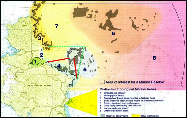
Click on the map for a page-sized
version.
Only faintly visible at the bottom of
the map (but here marked in yellow) is the navy testing area where anchoring
and fishing are prohibited. This de-facto marine reserve has not been included
in the proposal, even though it would have been a good starting point.
There has not been any research conducted to ascertain whether or not the
closed area has been beneficial to the environment.
Please note the 1994 proposal boundary (marked
with a dashed line)
and the smaller boundary recommended by the Steering Committee in 1991
(marked with a solid line),
which had the support of the locals.
Does size matter?
The 'best' size for a marine reserve depends on what you are trying
to protect. For some species a very small marine reserve may be enough
to protect a local population. For species that travel or migrate a very
large marine reserve may be required to be effective. Some very mobile
species may only take up temporary residence within a reserve. Research
is continuing into effective sizes for marine reserves. |
Even more important than size is the
right choice of boundary. Marine reserve boundaries must follow ecological
boundaries that are 'meaningful' to fish. A circle around an island such
as the Poor Knights, is such an ideal boundary. The boundaries in this
proposal are convenient to humans but insignificant to fish (straight lines,
territorial sea, promontories, etc.).
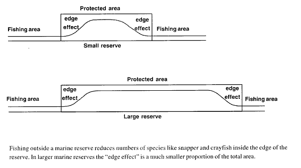
Whatever the size we know that fishing for snapper and crayfish just outside
marine reserve boundaries affects numbers in the reserve. Fishing causes
these species to be generally less abundant closer to the edges of reserves
compared to the middle. Recent research at Leigh shows reduced snapper
and crayfish numbers within two kilometres from the end of the five kilometre
long reserve. A bigger reserve minimises this effect. The illustration
below shows the 'edge effect' close to the reserve boundary.
Larger marine reserves enable a wider range of habitats to be protected.
So far marine reserves in the Auckland region are relatively small. A large
marine reserve at Great Barrier would protect a wide range of habitats,
suffer minimal effects from fishing at the edges of the reserve, and would
add significantly to the network of marine protected areas in the region.
Government policy is to protect 10% of New Zealand's marine environment
(the Territorial Sea to 12 nautical miles offshore) by 2010. To date we
have protected about 4% of our territorial sea, but just 0.1% around mainland
New Zealand [1]. so we have some way to go to meet this goal.
Government's policies are flawed. The
10% is based on a comparison of the sea with our national parks, which
is invalid. Scientists have not woken up to the seriousness of environmental
degradation in the sea.
[1] The 735,000 hectare Kermadec Islands marine reserve
is much larger than any other marine reserve around mainland New Zealand
and makes up about 3.9% of our territorial sea.
What's special about the north-east coast?
Along much of Great Barrier's north-east coastline, natural habitats
extend from the hilltops to the coast and offshore. This is uncommon in
northern New Zealand due to the extent of coastal development. Because
most of the land next to the proposed marine reserve is already public
conservation land we have a chance to protect an unbroken sequence of natural
habitats - land, estuary and sea - and manage them together. |
The link between land and sea is much
overestimated but the link between salt and fresh water is real. It is
important to remember that the sea is an entirely different environment
and that it needs to be managed in a different way. DOC has shown to be
the wrong managers for the sea but they are excellent for the land.
The north-east coast is characterised by exposed rocky shores but has a
wide range of coastal features: a sheltered enclosed estuary, an open surf
beach, sheltered sandy beaches, boulder beaches and more sheltered rocky
shores. Offshore there are sandy and muddy sediments, gravel beds, reefs
and deep rocky ground. Each of these features supports a collection of
marine plants and animals adapted to the local conditions.
Warm waters from the East Auckland Current bring a subtropical influence
to the marine life found there and increase its biological diversity. These
waters are often remarkably clear which, with the diverse seascapes and
rich marine life, makes for spectacular underwater viewing.
The area is one of the last strongholds of the giant packhorse crayfish
which migrate to shallow waters around north-east Great Barrier Island
each season.
There are better ways to protect packhorse
crayfish. Besides, they have not been seen for many years. The degraded
environment is not enticing them back.
The little modified Whangapoua Estuary is home to about one third of our
remaining endangered brown teal, New Zealand's unique little duck. Sand
flats and spits around the estuary are also important feeding and roosting
areas for a significant population of the threatened New Zealand dotterel.
Do fishermen threaten the brown teal
or dotterel?
Surveys undertaken within the proposed marine reserve show a wide variety
of habitat types, including remarkable deep water reef areas with black
coral, sponges and a wealth of invertebrate life.
Needles Point and Aiguilles Island
This exposed area at the northern end of the proposed reserve is characterised
by steep dropoffs and spectacular underwater scenery. Here, hydroids and
seasquirts feature at depths of 15-20 metres and schools of kingfish and
other pelagic fish are common. |
Rakitu island
Rakitu, a small island six kilometres off Whangapoua beach, has excellent
scuba diving. Its rocky shores plunge to depths of over 30 metres where
colourful sponges and other encrusting animals cover the rocks. Underwater
archways and caves are dotted with light-shunning hydroids or sea fans
and beautiful jewel anemones. Plankton-feeding demoiselles and blue maomao
are often present. In the archways low light levels allow marine life normally
found in much deeper water to live at depths accessible to snorkellers. |
Dragon Island, Harataonga Bay
Protected from wind and waves by Rakitu, Dragon Island is only a short
snorkel from Harataonga. The eastern end of the island hosts a variety
of deep gullies and huge boulders provide sheltered nooks and crannies
for an array of reef fish. orange and green wrasse and sandagers wrasse
give a subtropical flavour to the diverse fish fauna which include black
angelfish, demoiselle, porae, blue moki, red pigfish, john dory and abundant
red moki. |
Rainbow Reef
Named after a rainbow wrasse seen here, as well as the multi-coloured
sponges and other life on the seabed, this offshore reef sits between the
Harataonga coast and Rakitu Island. At 25 metres, it's an intermediate
habitat between the deeper sponge garden and shallower Ecklonia kelp forest.
Rock outcrops emerge from a gravel floor, which has a rich flora of small
red seaweeds. The rocky reef hosts Ecklonia, mixed with sponges and hydroids,
and harbours large fish such as porae and snapper. Multitudes of small
fishes hover over the reef feeding on plankton drifting by. |
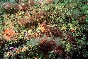
 A mixture of sponges and kelp
covers the low rocks at Rainbow
Reef. |
 Colourful sponges feature in deep
diving depths at Rakitu |
The photos shown here, taken by
Dr Roger Grace, appeared in the colourful 16-page brochure.
Although rendered rather dark, they
still reveal the degraded nature of the rocky shore environment. The depicted
orange finger sponges (Raspailia topsenti) are very hardy to degradation
by mud. It is remarkable that other types of sponge are absent from these
images. The kelp plants are all the same age since they were destroyed
in 1993. It is an unhealthy and unnatural forest now. The demoiselles in
the photo are all juvenile. In 1991 and in 2002 the majority of demoiselles
died in this area. In 2002 nearly all encrusting sponges, bryozoa and hydroids
died, as did many fish. |
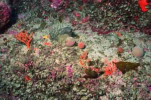
In this photo also the influence
of mud can be seen. The pink coloured rocks extend above the sea bottom.
They are angular in shape meaning that they are not moved very often, unlike
rolling stones.
All plants in the image are short-lived
and attached to the clean parts of the protruding stones. This is very
much the look of a degraded environment where grazers such as urchins,
chitons and top shells have disappeared recently. |
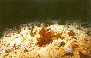
Red seaweeds on the gravel bottom.
|
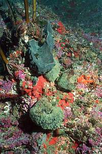
Deep water habitats
Deep rocky reefs occur to the south-east, north and north-east of Rakitu
Island, in depths of about 110 metres. surveyed by DOC in 2002 using a
special underwater camera, this rocky ground supports a rich variety of
sponges, black coral and other invertebrates, and is suitable habitat for
hapuku. Muddy sediments of the continental shelf to about 150 metres depth
extend to the 12-mile limit of the territorial sea. Deeper continental
shelf habitats like these, with their special seep water animals, are not
represented in other marine reserves. |
Ask for the video to see how much this
environment is covered in mud.
Whangapoua Estuary
Whangapoua Estuary is considered nationally important due to its large
size and undisturbed nature. Conservation land surrounds the estuary, which
provides habitat for an array of birds, shellfish and fish, as well as
the smaller bacteria and fungi on which the food chain depends. |
Conservation land does not surround
the estuary, but there is some near it. The bacteria and 'fungi' on which
the food chain depends are found in every drop of sea water and every square
millimetre of sea bottom.
The estuary 'feeds' the surrounding coastal marine communities with nutrients
supplied from the mangrove forest, seagrass and wetland areas. Snails,
crabs, worms and shellfish feed on micro organisms in the estuary, which
are then preyed on with each rising tide by snapper, yellow-eyed mullet,
flounder and rays. Along the water's edge wading birds feed on rich pickings
in the mud and sand.
Mangrove forests, seagrass and wetlands
do not supply nutrients. The mud from the land does. The number of marine
fish species depending on an estuary is very small but any species
may occasionally stray there. Estuaries like other sheltered places, help
recruitment (settling out from the planktonic stage) of some marine species.
Yellow eyed mullet has been observed to go upstream into freshwater and
wetlands to spawn.
The estuary supports significant numbers of the threatened New Zealand
dotterel and is a stronghold for one of our most endangered endemic ducks,
the brown teal. The spit is a high tide roost and the mudflats a feeding
ground for coastal birds, including the Pacific golden plover, banded dotterel,
bar-tailed godwit, variable oystercatcher and pied stilt.
Does fishing affect these?
 The
expansive pipi and cockle beds in the estuary are an important shellfish
gathering area for local people and tangata whenua. From consultation
it was noted that shellfish are less abundant elsewhere on Great Barrier
and that shellfish populations at Whangapoua are under pressure from
the summer influx of visitors to the island. Many locals have said
they should be able to continue to have a sustainable but small harvest
of the main shellfish species from the estuary. This view has been
endorsed by tangata whenua as kaitiaki of the estuary. The
expansive pipi and cockle beds in the estuary are an important shellfish
gathering area for local people and tangata whenua. From consultation
it was noted that shellfish are less abundant elsewhere on Great Barrier
and that shellfish populations at Whangapoua are under pressure from
the summer influx of visitors to the island. Many locals have said
they should be able to continue to have a sustainable but small harvest
of the main shellfish species from the estuary. This view has been
endorsed by tangata whenua as kaitiaki of the estuary.
Shellfish beds thrive from a moderate
amount of exploitation. The front page of the coloured brochure shows tracks
in the sand caused by cockles on the move from crowded areas. This is a
symptom of under-harvesting. By judicious harvesting, people can enhance
the productivity of cockle beds. The problem is that the MRA does not provide
enough flexibility for allowing a limited and supervised harvest. DOC is
the wrong agent and the MRA the wrong tool for marine reserves in the 21st
century.
To address these concerns, an exclusion zone could be established within
the Whangapoua Estuary to allow an ongoing sustainable harvest of shellfish.
DOC is seeking your views on whether an area should be set aside for shellfish
gathering and in what location.
What happens next?
After further consultation with tangata whenua, fishers, interested
groups and the Great Barrier community, and consideration of feedback on
this discussion document, DOC will make a formal application to the Director
General of Conservation for a marine reserve. Members of the public then
have two months, from the time the application is notified, to make submissions. |
The Minister of Conservation will make the final decision on the application,
which also requires agreement from the Ministers of Fisheries and Transport.
Locals are very wary of DoC handling
the submission. They have been through the process twice. When will a final
rejection be respected?
Establishing a marine reserve
Pre Statutory Process
(the proposal stage)
| Define objectives |
See objectives below |
| Initial consultation with interested groups |
1991 onwards
There was support for a small reserve. |
| Site survey and investigations |
1990 onwards |
| Draft proposals formulated and public feedback incorporated |
1991 & 1994
Rejected by a vast majority |
| Community consultation. Dicsussion document circulated for comment
before preparing formal application. |
2003 |
[The table of the pre-statutory and
statutory process have been left out to save space. Click
here for details, including the new statutory process
as proposed in the Bill now before Parliament. It bears no
relevance to this particular proposal since it forms part
of every marine reserve proposal. ] |
The objectives of a marine reserve on Great Barrier
island are:
-
To establish a marine reserve conforming to provisions of Sections 3(1)
and 3(2) of the marine Reserves Act 1971.
-
To protect and maintain a large section of the diverse marine ecosystem
and biodiversity on the north-east coast of Great Barrier island, that
is ecologically continuous with already protected adjacent terrestrial
habitats.
-
To protect a wide variety of marine habitats and their marine life, including
continental shelf deep water rocky and sediment habitats not represented
in marine reserves elsewhere.
-
To provide a safe haven for several species of marine animals presently
impacted by fishing, and to allow them to recover to their natural population
and social structure.
-
To provide a marine reserve which is large enough to minimise side effects
of fishing, and to provide a large central core area of protection to allow
ecological, social and behavioural characteristics of marine communities
to function without interference.
-
To provide opportunities for scientific study, including study of the relative
merits of large versus small marine reserves.
-
To provide opportunities for public enjoyment of non-extractive high quality
marine recreational activities.
-
To form a link in the national network of marine reserves in accordance
with New Zealand's Biodiversity Strategy (He Kura Taiao) and to contribute
towards the Government's target of protecting 10% of New Zealand's marine
environment by 2010.
Do you really think the above objectives will
be met? The era for coastal marine reserves has passed. Our seas can be
saved only by saving the land and by improving fisheries regulations. Our
only option is to stop the whole marine reserves process so that lies,
myths and fallacies can be ironed out and solutions found that will work.
An A4-sized
map is also available. Visit www.seafriends.org.nz
for more information on marine conservation and reserves.
NOW - Make your submission
- click this link to have your voice heard
|
