Now
and for the Future
![]()
![]()
![]()
![]()
![]()
![]()
![]()
![]()
![]()
![]()
| Conservation
Management Strategy Auckland 1995 – 2005 |
|
The establishment and management of marine reserves and other marine protected areas through statutory provisions administered by the Department. See also Marine Mammals chapter on page 287. There is a strong interest from many sectors of the community in the establishment of a comprehensive network of marine protected areas around the coast of New Zealand. The purpose of the network is to ensure, as far as possible, the preservation of representative samples of all classes of marine ecosystems, both typical and unique. Together these give New Zealand its own recognisable character. Marine ecosystems include all species of marine flora and fauna and their habitats. Legislation/ Maori Practices A number of statutes and traditional Maori resource management practices can provide for the protection of all or significant portions of the marine environment. These are administered by a range of agencies and authorities – the Department of Conservation, the Ministry of Agriculture and fisheries, Regional Councils and Iwi. Each practice and piece of legislation has a different purpose, and it is important to consider which will be most appropriate and effective when proposing protection of a given marine areas or resource. Marine protected areas where protected status is considered appropriate. The Department administers the Marine Reserves Act 1971, the Reserves Act 1977, the Conservation Act 1987, and the Marine Mammal Protection Act 1978, all of which can be used to protect marine values. The Marine Reserves Act 1971 states as its purpose “…this Act shall have effect for the purpose of preserving, as marine reserves for the scientific study of marine life, areas of New Zealand that contain underwater scenery, natural features, or marine life, of such distinctive quality, or so typical or beautiful, or unique, that their continued preservation is in the national interest”. Section 3.2(d) states “Subject to the provisions of the Act and to the imposition of such conditions and restrictions as may be necessary for the preservation of marine life or for the welfare in general of the reserves, the public shall have freedom of access and entry to the reserves, so that they may enjoy in full measure the opportunity to study, observe and record marine life in its natural habitat. A marine reserve may or may not abut the land. Amateur fishing is provided for in terms of Section 3(3) of the Act, whereby the Minister of Conservation by notice in the Gazette may authorise any person(s) to undertake the activity. However, no fishing is allowed in the two marine reserves in the Auckland Conservancy. For any new marine reserve proposal, fishing, other than by commercial fishers, may be provided for in terms of Section 5(9) of the Act by way of a condition of the Order in Council in cases where this is warranted. In addition to the Director General of Conservation, the following organisations and authorities may apply for a marine reserve to be established:
It is the Department’s function to process all applications. Protection of intertidal (foreshore) areas, vested in the Crown, can be achieved by setting an area apart as a reserve subject to the Reserves Act. It also provides for the extension of the boundaries of an existing reserve to mean low water springs. The Reserves Act provides for similar levels of protection to the marine reserves Act, but the provisions only extend over the foreshore, down to mean low water springs. In terms of s.49 of the Act, the Minister of Conservation may allow any qualified person to take specified specimens of animal or plant for scientific or education purposes from any reserve. However, no animal or plant can be removed or destroyed for any other purpose, including fishing, unless authorised. Any Crown foreshore area may be declared to be subject to the Conservation Act and held for conservation purposes in order for the habitats to be protected. The level of protection given to plants and animals within such an areas may vary, and activities such as fishing are not automatically excluded. If an activity is not damaging or likely to damage protected habitats or other features within the area under Conservation Act status, then it is unlikely to be prohibited. The Marine Mammals Protection Act provides for the protection of marine mammals, which may include the establishment of marine sanctuaries (see page 287 for more information on this Act). The Resource Management Act 1991 provides opportunities for the Department to become involved in statutory planning processes as they relate to the coastal marine area (refer to Statutory Planning and Coastal Policies chapters on pages 319 and 325). The purpose of the Act is to ensure sustainable management of the natural and physical environment, however, within the coastal marine area, sustainable management applies to all coastal resources except fisheries. Regional councils, with powers and responsibilities under the Resource Management Act 1991, must prepare regional coastal plans for the coastal marine area. The Ministry of Agriculture and Fisheries administers the Fisheries Act 1983, which provides for the management of marine plant and animal species, and for the establishment of taiapure – local fishery areas. The Ministry also administers the Treaty of Waitangi (Fisheries Claims) Settlement Act 1992 which provides for mataitai reserves to be established. Taiapure are provided for in the Maori Fisheries Act 1989, which amended the Fisheries Act. Taiapure are local fishery areas, in estuarine or littoral coastal waters which are of special significance to a particular iwi or hapu (either as a source of food or for spiritual or cultural reasons). The objective of the taiapure legislation is to provide for better recognition of rangatiratanga and of the right secured in relation to fisheries in Article II of the Treaty of Waitangi. Mataitai reserves are areas of traditional importance to tangata whenua. Maori reserves have been recognised in law since the 1870’s. The Treaty of Waitangi (Fisheries Claims) Settlement Act both enables the establishment of fishing reserves and recognises the rights of iwi to manage these. In both taiapure and mataitai reserves, any regulations need to be approved by the Ministry of Fisheries before implementation, must apply equally to all people, Maori and non-Maori, and must be consistent with sustainable management. In a mataitai reserve the committee is able to approve harvesting for marae purposes, even when the reserve is closed to all other harvesting. Traditional Maori views on fisheries and their management are being translated into practice by increasing use of traditional resource management practices such as rahui. Rahui can be understood as a temporary tapu to prohibit particular activities. Several forms are still prevalent. One form prohibits people from gathering food in an area for a specified period after a drowning. This prohibition is designed to separate people from the contaminated water and its products. The other main form of rahui is concerned with the conservation of species through prohibitions on the harvest of kaimoana. Existing Protection The Auckland Conservancy administers two marine reserves at time of publication. The Cape Rodney-Okakari Point Marine Reserve near Leigh is New Zealand’s first and premier marine reserve, established in 1975. The Kermadec Islands Marine Reserve was established in 1990, and lies approximately 1000km northeast of Auckland. It is an area of international significance, containing New Zealand’s only true subtropical marine ecosystem, and is the second largest protected area administered by the Department, after Fiordland National Park. Some foreshore (intertidal) areas are also protected under the Reserves Act. The nature reserves of the Kermadec Islands, Mokohinau Islands and Little Barrier Island protect all marine life above mean low water springs. The mangrove and estuarine foreshore of the Tauhoa Scientific Reserve in the Kaipara Harbour are also protected under the Reserves Act. The Tawharanui Marine Park protects an area of foreshore, seabed and coastal waters to 800 metres from mean high water springs on the northern coast of the Takatu Peninsula, and 200 metres from mean high water springs on the southern side. The area is managed by the Auckland Regional Council under bylaws made under the Harbours Act 1950. It is anticipated that these bylaws will be replaced where appropriate, by regional rules in the regional coastal plan. The Ministry of Agriculture and Fisheries administers Fisheries Act regulations which prohibit the taking of any marine life. In 1981, when the Marine Park was established, the Ministry published special fisheries restrictions which prohibited fishing on most of the northern side of the peninsula; however fishing is still allowed on the southern side. Rahui have been imposed by local iwi at Karekare, Long Bay, Eastern and Cheltenham Beaches to protect shellfish beds. These beaches have also been closed for the taking of shellfish under section 85 of the Fisheries Act 1983 for a two year period. Such use of the Fisheries Act provides a means for rahui to be recognised in law. Marine reserve applications are being processed for areas around Pollen Island in the Upper Waitemata Harbour and the Long Bay/ Okura River area on Auckland’s East Coast Bays. The Department is also investigating a marine reserve proposal for the northeastern coast of Great Barrier Island. The character of the Auckland marine environment The character of the Auckland Conservancy is derived from its intricate coastal setting and its marine environments. In the north, the isolated mid-oceanic Kermadec Islands rise sharply above the Kermadec Trench, one of the deepest submarine features on earth. This complex biologically rich area, intermediately placed between temperate mainland New Zealand waters and subtropical Tongan waters is fully protected to the limit of New Zealand’s territorial sea (12 nautical miles) by the Kermadec Marine Reserve. Mainland northeastern New Zealand coastal waters are affected peripherally by warm oceanic currents which cross the northern Tasman Sea from eastern Australia to merge with colder southern waters. On the west, colder currents from the southern Tasman Sea sweep close to the New Zealand coast. The mainland Auckland Conservancy presents bold faces to these oceanic influences along outer Barrier Islands and the West Coast. On both the east and West Coasts, these powerful oceanic currents confront rocky coasts. On each coast, the waters penetrate deeply into the region, producing dramatic contrasts with the outer exposed coasts, as every variety of sheltered, open, hard and soft marine environments receive the waters. In the heart of Auckland, the coastal waters from east and west almost meet, and play a major role in determining the geography of the metropolitan area, while their diurnal ebb and flow combine to affect its mild maritime climate. To the east, the broad expanse of the Hauraki Gulf provides a relatively sheltered marine environment without parallel in New Zealand. Along its coasts are repeating patterns of rocky shores and headlands and sandy bays, interrupted by small shallow estuaries at river and stream mouths. At the head of the Gulf, the waters from the Waitemata Harbour on the west, and in the southeast the broad Firth of Thames. On the West Coast, the confronting barriers of rock and sand are broken only at the narrow Manukau and Kaipara Harbour entrances, both of which open out into large shallow harbours edged by the detailed and intricate pattern of a drowned coastline with some bolder headlands and cliffs, with sandy beaches, deeply penetrating estuaries and broad muddy intertidal flats. Developing a marine protected area network To be truly representative of the diversity of marine ecosystems and features of the Auckland Conservancy, a network of marine protected areas needs to include:
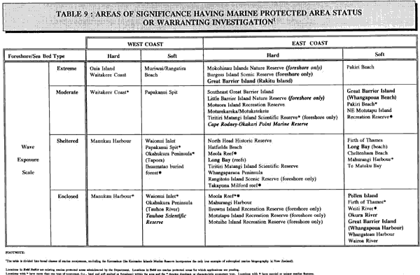
Achieving representativeness To help distinguish the different types of marine ecosystem found in the Conservancy, a classification system has been developed. Table 9 summarises the main classes of marine environment which contribute to the character of the Auckland Conservancy and which distinguish it from other parts of New Zealand. Any simple scheme to capture the diversity and richness of marine environment in Auckland will have inadequacies. However, three major characteristics have been distinguished – biogeography, wave exposure and substratum type. Biogeography refers to the character, patterns and distribution of different physical and biological elements of marine ecosystems. In addition to the distinctive subtropical Kermadec area, Auckland has distinctly different west and east coast marine ecosystems. Wave exposure relates to the power of the sea, the length of fetch and the size of the waves which can effect the marine environment, both on the coast and out at sea. The two extremes of wave exposure are represented by very wild and waveswept offshore areas, such as the Mokohinau Islands, and the enclosed upper reaches of harbours, such as Pollen Island in the Waitemata Harbour. Between these two extremes is a continuum scale, but two intermediate stages are open moderately wave-exposed coasts with a limited fetch or which are only subject to very high wave conditions occasionally, typified by Pakiri Beach, and the wave-protected coasts with very short fetch and/or headlands or other deflectors of the wave energy, such as Cheltenham Beach/ North Head. Substratum type is a complex mixture of many factors, but a simple distinction can be easily and readily made between hard (rocky) foreshore and sea bed, such as Meola Reef, and soft (sand or mud) foreshore and sea bed, such as the mangrove forests of the Kaipara Harbour. Consideration of these three characteristics provides a total of 16 different ecosystem combinations or classes. To develop a comprehensive network of marine protected areas in the Auckland Conservancy, it is desirable to protect at least one example of each these 16 classes. It may also be desirable to protect several areas within one particular ecosystem category in order to capture the diversity and richness of marine features found in the Conservancy. Some sites are grouped together within an ecosystem class which are recognisably quite different in character. For example under the class of “east coast, wave sheltered, hard coasts” are both the volcanic basalt foreshore rocks of Takapuna reef and the Waitemata-series sedimentary, sandstone, wave-cut platform reefs of Long Bay. Because these areas are of different hardness (sandstone erodes much faster than basalt), colour (lighter coloured sandstone holds heat differently to dark basalt) and shape (sandstone erodes to a flat reef platform, whereas basalt retains its nooks and crannies) the species found at each location are quite different. Other areas such as the Weiti Spits, Te Tokaroa (Meola) Reef, Takapuna Reef, and the Ihuamatao buried forests are important because they provide unique records of geomorphologic processes which helped shape the Auckland marine landscape. In the case of northeast Motutapu, which is in the vicinity of the Motutapu Outdoor Education Centre, the educational value of a marine protected area would be of national significance. The achievement of representativeness is likely to include the protection of at least 10% of the coastal area and seas of each biogeographic region which lies with the Auckland Conservancy boundary. The adequacy of the representativeness of protected areas will need to be monitored. Selecting sites for marine protected area investigation The main legal mechanisms the Department can use when seeking to formally protect marine ecosystems are the Reserves Act, Conservation Act and the Marine Reserves Act. With reference to Section 3 of the Reserves Act, the meaning of ‘conservation’ as defined in the Conservation Act, and Section 3(1) of the Marine Reserves Act (see Appendix 20), the Department has developed a list of sites it believes are the most significant in terms of their natural values, using the following criteria:
Criteria
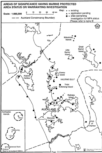
Information for site assessment has been derived from a range of sources, including the Department’s Coastal Resource Inventory (1990), the Marine Reserves Forum, and from submissions received from the public on the Draft Conservation Management Strategy, Auckland (1993). The Marine Reserves Forum, an initiative of communities of interest in Auckland, advises the Department on matters relating to marine protection. Members include central and regional agencies, conservation organisations and user groups. The statutory mechanism to be used to protect any areae would be determined as part of any investigation. The sites identified as warranting investigation for marine protected status are shown in Table 9. It is not envisaged that the Department will investigate all sites, and therefore further priorities need to be established. Priorities for investigation Further criteria have been developed to help determine which of these sites will be priority areas for investigation by the Department over the next ten years. These criteria are primarily concerned with degree of threat, achievability of establishing and looking after a marine protected area, and the benefits to the wider community. These criteria have been used as guides to determine the need for urgency of action in investigating areas, and not all criteria are necessarily met for any one priority site. Further Criteria 1. High level of threat to natural values of the area by use
or change Consideration of the above criteria in relation to the sites identified as warranting investigation has resulted in a list of ten areas which the Department will investigate as a matter of priority. These are detailed in implementation 41.1.2 and 41.1.3 NB The criteria on pages 311 and 314 can also provide a useful guide for other agencies and organizations in assessing the desirability of promoting the protection of any given marine area. Marine Reserves Management In terms of the Marine Reserves Act, the Department has responsibilities to manage a marine reserve so as to protect the marine life and its habitat, as well as to ensure the underwater scenery and natural features of the area are preserved as far as possible in their natural state. Other marine protected areas must also be managed in accordance with the provisions of the Act under which they are protected. While all marine protected areas have certain management requirements in common, including compliance/ law enforcement, research, monitoring, and educational advocacy, the emphasis will vary, depending upon the area’s accessibility and particular constraints and opportunities presented at each location. For example, the management requirements of the Cape Rodney-Okakari Point Marine Reserve and the Kermadec Marine Reserve are quite different. The former, being just north of the Auckland urban area, is subject to extensive scientific study as well as high recreational use by both the general public and by commercial dive training schools. More recently, a commercial glass bottom boat tourist operation has begun to operate within the reserve. Because of the variety of non-extractive uses and activities which occur within this reserve, and which are generally undertaken by different groups, (that is, the general public like to simply picnic, walk on the beach and/ or snorkel/ swim in the reserve, whereas dive club members prefer to only scuba dive), there is potential for conflict between these competing uses. This particular management issue is to be directly addressed as part of a joint University of Auckland and Department of Conservation study on future management options, and in the preparation of a proposed Conservation Management Plan for this area. (Refer to Cape Rodney-Okakari Point/ Leigh chapter on page 105). In order to ensure illegal fishing activities are minimised, the
implementation of an effective compliance/ law enforcement programme
is essential. The terms ‘compliance’ and ‘law
enforcement’ whilst having similar connotations, do not mean
the same thing when used by the Department. ‘Compliance’
encompasses all of the activities, such as education programmes,
undertaken by the Department to encourage people to adhere to any
regulations, bylaws or offence provisions of Acts, rather than ‘break
the law’. The Kermadec Marine Reserve in comparison with the Cape Rodney-Okakari Point Reserve is both remote and vast and hence management requirements are different. Here, special emphasis is placed on education programmes to ensure that visitors are aware of the values of the reserve. Because of the distance from New Zealand, the use of volunteer assistance with compliance/ law enforcement is not feasible. Instead, close liaison and cooperation with agencies such as Ministry of Agriculture and Fisheries and the New Zealand Defence Force are important. As scientific study is specifically provided for in terms of the Marine Reserves Act, the Department has a responsibility to assess, in accordance with the legislation, any applications submitted by researchers. Scientists may also want to undertake study in other marine protected areas. The assessment of such applications is undertaken in accordance with the relevant legislation and Departmental guidelines. The Department monitors marine protected areas for a variety of reasons, such as tracking changes in the near-natural environment of a marine reserve, or monitoring the impact of visitor use in a marine reserve to be sure that any adverse effects are minimised. Objectives 41.0.1 Create a network of up to 20 representative marine protected areas within the Auckland Conservancy by the year 2005, to contribute to the protection of representative samples of all classes of marine landscapes and ecosystems, both typical and unique, and which in its aggregate represents Auckland’s own distinctive marine character. 41.0.2 Manage marine protected areas in accordance with the provisions of the Act under which they are protected.
41.1.2 Include the following sites for investigation, and where
appropriate implement protection: 41.1.3 Seek to include within the adjacent reserves the foreshores
of the following: 41.1.4 Consult with Iwi, the Auckland Marine Reserves Forum, territorial local authorities, regional councils, the Ministry of Agriculture and Fisheries, Ministry of Transport, Department of Survey and Land Information, people likely to be affected such as those associated with commercial and recreational fishing and the community generally, to implement the establishment of the marine protected areas network. 41.1.5 Where existing marine protected areas, or possible future locations, are associated with or adjacent to regional parks, continue to liaise with the Auckland Regional Council to develop management programmes which integrate with and are complementary to the Auckland Regional Council’s park management. 41.1.6 Provide advice on policy and procedures in line with this Strategy, to those organisations proposing marine reserves and other marine protected areas. 41.1.7 Ensure that the local authorities in and adjoining the Conservancy have regard to the contents of this Conservation Management Strategy when preparing their planning documents under the Resource Management Act. 41.1.8 Use opportunities to achieve marine protection through statutory mechanisms other than those for which the Department is responsible (see section on Statutory Planning page 319). 41.1.9 Support the establishment of marine protected areas, where traditional Maori resource management practices are used (rahui), and where statutory recognition of these practices is implemented, eg. Mataitai areas, taiapure areas, closures under section 85 of the Fisheries Act, and where the objectives include fishery resource conservation. 41.1.10 Liaise with the Ministry of Agriculture and Fisheries and Ministry of Transport over the establishment of any particular marine reserve, given the concurrence roles of the Ministers of Fisheries and Transport. 41.1.11 Develop and implement compliance and law enforcement action plans for the Cape Rodney-Okakari Point and Kermadec Islands Marine Reserves as a matter of priority to ensure that the provisions of the Marine Reserves Act as they relate to those reserves are adhered to. 41.1.12 Develop and implement a compliance/ law enforcement action plan for any future marine reserve or marine protected area. 41.1.13 Seek to ensure that activities within the Cape Rodney-Okakari Point Marine Reserve and the adjacent land reserves are managed so as to protect the marine reserve for scientific study and its marine life and underwater scenery, while not detracting from visitors enjoyment. 41.1.14 Consider entering into management agreements with appropriate individuals/ agencies/ iwi regarding compliance and law enforcement and in monitoring other marine protected areas. 41.1.15 Investigate the need for an advisory committee for the management of any given marine protected area. 41.1.16 Process all applications for scientific study in accordance with the relevant legislation and/ or Departmental guidelines. 41.1.17 Facilitate scientific monitoring of the conditions of certain habitats and species within marine reserves and other marine protected areas. 41.1.18 Co-ordinate with Northland and Waikato Conservancies over the establishment of a marine protected area network. 41.1.19 Carry out publicity and education programmes to increase
public understanding, appreciation and enjoyment of marine protected
areas and their values, to assist compliance with regulations, and
to encourage community involvement in the management of marine protected
areas.
|